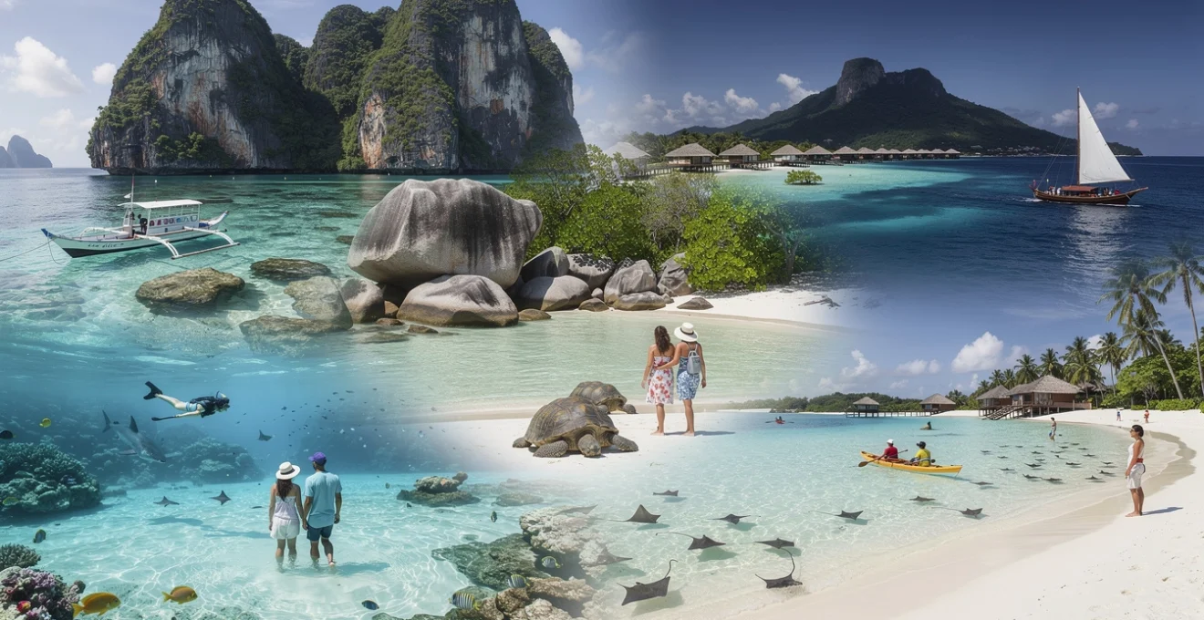
Crystal-clear waters represent the pinnacle of tropical beauty, drawing millions of travellers annually to remote islands where visibility can extend dozens of metres beneath the surface. These destinations share remarkable characteristics: minimal coastal development, thriving marine ecosystems, and geological formations that create conditions for exceptional water clarity. From the powdery silica sands of the Maldives to the limestone karst formations of Palawan, certain island destinations have perfected the art of preserving their aquatic environments. The science behind water clarity involves multiple factors—sediment composition, phytoplankton levels, wave action patterns, and human impact—all combining to create those mesmerising shades of turquoise and sapphire that dominate holiday brochures. Understanding what makes these destinations special helps you appreciate the delicate balance between tourism and conservation that keeps these waters pristine.
Maldives atolls: pristine lagoons and marine visibility exceeding 30 metres
The Maldives archipelago consists of 26 natural atolls formed from ancient volcanic islands, creating a chain of coral formations that stretch across 90,000 square kilometres of the Indian Ocean. What sets Maldivian waters apart is their oligotrophic nature—essentially nutrient-poor conditions that limit algae growth, resulting in exceptional transparency. The atoll structure itself acts as a natural filtration system, with barrier reefs protecting interior lagoons from sediment whilst allowing tidal exchange that oxygenates the water. Visibility regularly reaches 30-40 metres during the dry season (November to April), making the Maldives a premier destination for underwater photography and marine observation. The white coral sand composition reflects sunlight through the water column, creating those characteristic luminous blue gradients that appear almost artificial in their intensity.
Baa atoll UNESCO biosphere reserve: Plankton-Rich waters and manta ray corridors
Baa Atoll earned UNESCO Biosphere Reserve status in 2011, recognising its exceptional biodiversity and unique oceanographic conditions. During the southwest monsoon season (May to November), nutrient upwellings create plankton blooms that attract massive aggregations of manta rays to sites like Hanifaru Bay. These seasonal feeding frenzies can involve over 200 individual mantas in a single day, creating one of nature’s most spectacular marine events. Despite the increased plankton levels during monsoon months, water clarity remains impressive due to the temporary nature of these blooms and efficient tidal flushing. The reserve encompasses 139 islands, with strict environmental regulations limiting development and protecting critical habitats including seagrass meadows and coral gardens that contribute to overall water quality.
South ari atoll: whale shark aggregation zones and coral garden ecosystems
South Ari Atoll hosts year-round whale shark populations, unlike most destinations where these gentle giants only appear seasonally. The atoll’s unique position in ocean current patterns creates consistent food availability, with zooplankton concentrations that support juvenile whale sharks throughout their development. Water transparency here allows snorkellers to observe these 10-metre creatures from the surface, whilst their spotted patterns remain clearly visible even at depth. The southern reef systems feature staghorn and table coral formations that create complex three-dimensional structures, providing habitat for over 1,100 species of fish. Research stations monitoring these ecosystems have recorded Secchi disk readings—a standard measure of water clarity—regularly exceeding 25 metres, placing South Ari among the world’s clearest tropical waters.
North malé atoll: house reef diving and Shallow-Water snorkelling sites
North Malé Atoll concentrates the highest density of resort development in the Maldives, yet maintains remarkable water quality through strict environmental protocols and the natural advantage of strong tidal currents. House reefs—coral formations directly accessible from resort beaches—offer immediate access to pristine underwater environments without boat transfers. Sites like Banana Reef and HP Reef feature dramatic wall formations dropping from shallow lagoons to depths exceeding 30 metres, creating diverse habitats within compact areas. The proximity to Velana International Airport makes North Malé the most accessible atoll, allowing you to experience world-class water clarity within hours of arrival.
Huvahendhoo island: powder-fine silica sand and turquoise gradient waters
Huvahendhoo Island, located within South Ari Atoll, is a textbook example of how geology shapes water clarity. Its beaches are composed of ultra-fine silica and coral sand, which scatter light evenly and create a distinct turquoise gradient that deepens into cobalt blue beyond the reef edge. Because the island lacks major runoff sources and has minimal vegetation close to the shore, very little sediment enters the lagoon, preserving its glass-like transparency even after periods of strong wind. For travellers seeking crystal-clear waters for swimming with children, the shallow lagoon here offers a calm, pool-like environment with visibility that often exceeds 20 metres.
Resorts on Huvahendhoo typically maintain strict guidelines on greywater management and reef protection, reducing anthropogenic impacts that could otherwise cloud the water. Snorkelling from the beach reveals healthy coral bommies, sand channels, and occasional turtle or reef shark encounters in just a few fin kicks from shore. If you are interested in underwater photography, the combination of pale substrate and clear water creates excellent natural lighting conditions, allowing you to capture sharp images without powerful strobes. Visiting between December and April usually provides the clearest conditions, as the northeast monsoon brings calmer seas and more stable visibility across the lagoon.
Palawan archipelago, philippines: limestone karst formations and azure seascapes
The Palawan Archipelago in the western Philippines is frequently cited as one of the world’s last ecological frontiers, thanks to its rugged limestone karsts, dense forests, and remarkably transparent coastal waters. Here, towering cliffs plunge into bays where the water can appear almost neon under midday sun, a result of shallow sandy bottoms and low levels of suspended sediment. Unlike many heavily developed tropical coasts, significant portions of Palawan’s shoreline remain sparsely populated, limiting nutrient runoff and helping maintain oligotrophic, crystal-clear conditions. For island getaways best known for crystal-clear waters, Palawan offers an ideal mix of dramatic landscapes and accessible, shallow reefs.
Oceanographic factors also play a role. Palawan sits between the South China Sea and the Sulu Sea, with complex current systems that continually flush coastal areas and prevent stagnation. Protected marine zones and restrictions on destructive fishing practices have further helped maintain coral cover and seagrass meadows, both of which act like natural filters. As a result, snorkellers and divers can often enjoy 20–30 metres of visibility, especially during the dry season from November to May. Whether you are paddling through hidden lagoons or drifting over coral gardens, the sense of immersion in pure, clear water is hard to match.
El nido’s bacuit bay: hidden lagoons within razor-sharp limestone cliffs
Bacuit Bay, just offshore from El Nido town, is renowned for its maze of limestone islands, where razor-sharp karsts encircle jade and turquoise lagoons. These karst formations are composed of soluble limestone that has been sculpted over millions of years, creating sheltered basins with limited wave energy and very little sediment disturbance. Because most of the surrounding slopes are rocky rather than muddy, rainfall carries minimal particulate matter into the water, preserving exceptional clarity across much of the bay. When sunlight filters through narrow cliff openings into inner lagoons, the water can look almost backlit, as if illuminated from below.
Access to many of Bacuit Bay’s hidden lagoons is managed via regulated boat tours that limit daily visitor numbers and control where vessels can anchor. This zoning reduces propeller-induced turbidity and protects seagrass beds that stabilise the sandy substrate. For travellers, this means you can glide over coral heads in a kayak and literally count starfish on the bottom several metres below. Early-morning trips often offer the best conditions for glassy-smooth surfaces and mirror-like reflections. Wondering when to visit for the clearest water? Aim for the shoulder months of November and early March, when skies are generally dry but peak crowds are yet to arrive.
Coron island: kayangan lake thermocline layers and barracuda lake visibility
Coron Island, north of Palawan’s main spine, is famed for twin icons of water clarity: Kayangan Lake and Barracuda Lake. Kayangan Lake, often billed as one of the cleanest lakes in Asia, sits in a steep limestone bowl where rainfall and underground springs feed a body of water that is part fresh, part brackish. Thermocline layers—where water temperature changes abruptly with depth—are clearly visible to snorkellers, forming shimmering bands that look like heat haze underwater. Despite these layers, suspended particles remain low, allowing you to see rock formations and tree roots descending many metres beneath the surface.
Barracuda Lake is equally striking, with a mix of freshwater and seawater forming distinct haloclines and temperatures that can reach 30°C or more in deeper layers. Visibility here often exceeds 20 metres, giving divers the surreal sensation of flying through a submerged canyon with perfectly lit rock walls. Around Coron’s outer reefs and wreck sites, clear water is further enhanced by limited coastal development and strong flushing from the open sea. If you are planning to combine wreck diving with crystal-clear reef snorkelling, consider visiting between February and April, when sea conditions are typically calm and rainfall is minimal.
Nacpan beach twin coastline: white silica composition and wave refraction patterns
Nacpan Beach, about an hour’s drive from El Nido, offers a different perspective on Palawan’s clear waters. This twin-coastline beach features a long arc of pale, silica-rich sand that reflects significant amounts of light into the water column, giving the nearshore shallows a warm golden-turquoise glow. Because the seabed slopes gently, wave energy dissipates gradually, reducing the resuspension of sand and helping to keep the water clear for swimmers wading out tens of metres from shore. On calm days, you can see your toes clearly even in waist-deep water, a hallmark of high-quality beach environments.
Wave refraction patterns around the twin headlands at either end of Nacpan create natural zones of calmer water where sediment settles out more quickly. These pockets can be ideal for stand-up paddleboarding or casual snorkelling, especially during the dry season when swell is minimal. Facilities along the beach remain relatively low-rise and spread out, which reduces concentrated runoff points and helps preserve that postcard-perfect transparency. For photographers, late afternoon light bathes the water and sand in soft hues, making Nacpan one of Palawan’s best locations for capturing long-exposure shots of gentle surf rolling over glassy shallows.
Port barton marine sanctuary: seagrass meadows and juvenile fish nurseries
Port Barton, a quieter coastal town between El Nido and Puerto Princesa, has gained a reputation as a laid-back alternative with equally impressive water clarity. Its marine sanctuary encompasses coral patches, sandy bottoms, and extensive seagrass meadows that function as vital nursery habitats for juvenile fish and invertebrates. These seagrass beds act like underwater filters, trapping fine sediments and absorbing nutrients that could otherwise fuel algal blooms. The result is a nearshore environment where the water often appears transparent down to several metres, especially on days with low wind and gentle tides.
Boat tours here typically visit small islands and sandbars where you can snorkel in protected coves with visibility in the 15–20 metre range. Because Port Barton has stricter limits on boat numbers and fishing within sanctuary zones, you are more likely to encounter schools of reef fish, turtles, and even occasional dugongs in clear, undisturbed water. If you are looking for island getaways best known for crystal-clear waters but prefer a less crowded scene than El Nido, Port Barton offers an appealing balance. Staying in eco-lodges that manage waste responsibly also helps support ongoing local efforts to keep these waters as pristine as possible.
Seychelles granitic islands: oligotrophic waters and bathymetric clarity
The Inner Seychelles, particularly the granitic islands of Mahé, Praslin, and La Digue, sit atop ancient continental fragments rather than coral atolls, giving them a unique combination of rugged topography and clear, nutrient-poor waters. Their isolation in the western Indian Ocean means fewer large river systems discharge into the surrounding sea, resulting in low sediment and phytoplankton levels. This oligotrophic setting contributes to what scientists call high bathymetric clarity: the ability to see seabed features at surprising depths. In the right conditions, snorkellers can make out granite boulders and sandy patches 20 metres below the surface, especially on the leeward sides of the islands.
Because the shorelines are often rocky rather than heavily vegetated, rainfall does not wash significant amounts of soil into the bays. Add in the protection offered by fringing reefs and seagrass meadows, and you have one of the clearest marine environments in the Indian Ocean. For travellers, this translates into beaches where the turquoise-to-deep-blue gradient is sharp and well-defined, almost like layers in a painting. Visiting between May and October, during the southeast trade wind season, often provides calmer sea states and consistently high visibility on the sheltered coasts.
Anse source d’argent, la digue: granite boulder formations and tidal pool ecosystems
Anse Source d’Argent is one of the world’s most photographed beaches, and the clarity of its water is a major reason why. Giant granite boulders, smoothed by millions of years of erosion, break up the shoreline into sheltered coves where wave energy is minimal. Inside these pockets, shallow sandy floors and scattered seagrass create natural “tidal lagoons” that fill and drain gently with each tide. Because the water remains shallow over a light-coloured substrate, it appears exceptionally bright and transparent, especially under midday sun when the sun’s rays penetrate almost vertically.
At low tide, numerous rockpools form between the boulders, becoming micro-ecosystems that host juvenile fish, small crustaceans, and sea cucumbers. Exploring these pools is like peering into miniature aquariums, offering a tangible example of how clear water showcases biodiversity. To preserve this delicate environment, local authorities restrict motorised water sports and control beach development. If you are planning a visit, arriving early in the morning not only avoids crowds but also increases your chances of photographing glass-calm surfaces and perfectly reflected boulders in water so clear it seems invisible.
Anse lazio, praslin: north-west monsoon patterns and seasonal transparency fluctuations
Anse Lazio on Praslin combines a sweeping crescent of golden sand with clear, gently shelving water that makes it ideal for swimming and casual snorkelling. However, water clarity here is not constant year-round; it fluctuates with the region’s monsoon patterns. During the northwest monsoon (roughly November to March), the bay is more directly exposed to wind and swell, which can stir up fine sand and slightly reduce visibility. By contrast, the southeast trade wind season often brings calmer, clearer conditions to the northern side of the island, allowing suspended particles to settle and restoring that signature turquoise transparency.
These seasonal shifts are a good reminder that even the clearest beaches are part of dynamic systems influenced by global climate patterns. Planning your trip with these cycles in mind can significantly enhance your experience. If top-notch visibility for snorkelling is your priority, target late April to early June or September to early November, when transitional conditions often mean light winds and stable seas. In these months, it is not unusual to float above granite outcrops and see schools of fusiliers and parrotfish feeding on algae-covered rocks with astonishing clarity.
Curieuse island marine national park: giant tortoise habitat and mangrove channels
Curieuse Island, just off Praslin, is a designated Marine National Park known both for its free-roaming Aldabra giant tortoises and its clear, sheltered coastal waters. The island’s northern bays and mangrove-lined channels form a semi-enclosed system where tidal currents gently flush the area without generating large waves. Mangrove root systems trap sediment and stabilise the shoreline, preventing erosion that could otherwise cloud the water. As a result, the shallows around Curieuse often resemble a natural aquarium, with sandy bottoms, scattered seagrass patches, and coral heads visible in fine detail from the surface.
Kayaking through the mangrove channels is an excellent way to appreciate the interplay between clear water and coastal vegetation. The tannin-rich roots and leaves filter runoff like a biological sieve, much as a coffee filter clarifies liquid by capturing fine particles. Conservation regulations strictly limit construction and motorised traffic in the park, which helps maintain low pollution levels and healthy seagrass meadows. For visitors, this means you can combine tortoise encounters on land with snorkelling sessions in water clear enough to watch juvenile fish weaving among mangrove roots and coral rubble.
Cook islands polynesian waters: volcanic sand contrast and reef-protected shallows
The Cook Islands, scattered across a vast stretch of the South Pacific, are celebrated for lagoons that look almost unreal in their clarity and colour. Unlike coral atoll nations with exclusively white-sand beaches, the Cook Islands feature a mix of volcanic and coral sands, creating striking contrasts between dark seabeds and luminous turquoise shallows. Fringing and barrier reefs encircle many of the main islands, forming calm, reef-protected lagoons where wave action is relatively low. This reduction in turbulence allows fine sediments to settle, resulting in consistently clear water across broad, shallow platforms.
Because local communities rely heavily on the lagoon for food and cultural activities, there is growing emphasis on sustainable fishing and marine protection. Community-led ra’ui (traditional no-take zones) and modern marine reserves work together to safeguard coral cover and water quality. For travellers, this means you can paddleboard, kayak, or simply wade in knee-deep water while watching coral formations and tropical fish just beneath the surface. If you are seeking island getaways best known for crystal-clear waters but with a strong sense of Polynesian culture, the Cook Islands are a compelling choice.
Aitutaki lagoon: 15-kilometre barrier reef and honeymoon island sandbars
Aitutaki’s lagoon, enclosed by a 15-kilometre horseshoe-shaped barrier reef, is often described as one of the most beautiful in the world. The reef acts as a vast natural breakwater, calming the waters inside and preventing large ocean swells from disturbing the sandy seabed. Because the lagoon is relatively shallow—often less than 10 metres deep across huge areas—sunlight penetrates easily, illuminating coral heads, rays, and sandbars in exquisite detail. On clear days, you can stand in waist-deep water and see ripples in the sand several metres away, as if you were looking through air rather than water.
Honeymoon Island and neighbouring sandbars are classic examples of how sand and light shape the perception of water clarity. These narrow spits of white coral sand push into the lagoon like fingers, surrounded by ultra-shallow water that glows almost neon blue under strong sun. Boat tours often anchor in just a metre of water, letting you step directly into a natural “infinity pool” that seems to merge with the horizon. To experience peak clarity, aim for mid-tide during sunny conditions, when surface chop is minimal and the lagoon becomes a perfect canvas of blues and greens.
Rarotonga’s muri lagoon: four motus and kayaking transparency zones
Muri Lagoon, on the southeast corner of Rarotonga, is framed by four small motus (islets) that help break up wind and waves, creating multiple pockets of calm, shallow water. These zones act like natural swimming pools, with sandy bottoms and low turbidity making them ideal for beginners learning to snorkel or paddleboard. Because the lagoon is protected from heavy surf by an outer reef, sediment disturbance is minimal, and even on breezy days you can usually find sections where the water remains strikingly clear. It is not uncommon to spot blue starfish, sea cucumbers, and schools of goatfish from a kayak without ever getting wet.
Local operators increasingly use non-motorised craft such as outrigger canoes and stand-up paddleboards to minimise fuel spills and noise pollution. This shift supports both marine conservation and the visitor experience, as fewer boat wakes mean less stirred-up sand and better visibility. Travelling with family and wondering if the water is safe and clear enough for children? Muri Lagoon’s gently sloping depths and protected transparency zones make it one of the Cook Islands’ most family-friendly spots for enjoying crystal-clear lagoon water.
One foot island, aitutaki: secchi disk readings and ultra-shallow wading areas
One Foot Island, or Tapuaetai, sits within Aitutaki’s lagoon and has become synonymous with impossibly clear, shallow water. Scientific measurements using Secchi disks—a simple tool for gauging water transparency—often show readings of 20–25 metres in deeper channels nearby, underscoring just how clear the surrounding lagoon can be. Closer to shore, vast areas of ultra-shallow water barely reach knee height, effectively transforming the sea into a sunlit wading pool. Because these flats are protected from strong currents and heavy boat traffic, suspended sediments are minimal and visibility to the sandy bottom is almost perfect.
Walking across these shallows can feel like stepping across a sheet of liquid glass, with tiny ripples distorting coral fragments and shells underfoot like a moving magnifying glass. The same optical principles that let Secchi disks disappear at depth also explain why your feet remain visible even tens of metres from the beach: low particle loads and a bright, reflective seabed. Visitors are encouraged to stay within marked areas to avoid trampling fragile organisms, helping maintain the lagoon’s clarity for future travellers. If you have ever wondered what “swimming in a postcard” feels like, One Foot Island comes remarkably close.
Zanzibar archipelago: indian ocean currents and coral atoll ecosystems
The Zanzibar Archipelago, off Tanzania’s coast, owes much of its water clarity to its position within the flow of the Indian Ocean Equatorial Current. This steady movement of relatively clean, offshore water helps flush the channels between islands and maintain low nutrient levels, which in turn limits algal blooms. Coral reefs fringe large sections of Unguja (often called Zanzibar Island) and Pemba, forming natural barriers that protect inner lagoons and sandy beaches from heavy surf. Where coastal development has been kept in check, these conditions combine to create the kind of clear, aquamarine shallows that have made Zanzibar a byword for tropical escapes.
Visibility around the outer reefs can reach 20–30 metres during the calmer months from December to March and again in August and September. These same ocean currents bring in plankton that supports thriving reef ecosystems without overwhelming them, striking a balance between productivity and clarity. For travellers, this makes Zanzibar one of the best island getaways best known for crystal-clear waters that also offer rich marine life for snorkelling and diving. From shallow coral gardens to dramatic drop-offs, the underwater scenery is consistently enhanced by good to excellent visibility.
Mnemba island conservation area: hawksbill turtle nesting beaches and drop-off walls
Mnemba Island, a small private island off Zanzibar’s northeast coast, is encircled by some of the clearest waters in the region. Designated as a Marine Conservation Area, it benefits from strict limits on fishing, anchoring, and guest numbers. The island’s surrounding reef forms a near-complete ring, with shallow coral gardens on the inside and steep drop-off walls on the ocean-facing side. These vertical walls, plunging to depths beyond recreational diving limits, create dramatic scenes where clear blue water seems to fade into endless cobalt as you look down.
Hawksbill and green turtles regularly nest on the island’s beaches, a sign of relatively undisturbed coastal conditions and healthy seagrass meadows offshore. Conservation initiatives monitor nesting activity and regulate light pollution, which can affect hatchling orientation. Because boat traffic is controlled and many dive sites use permanent moorings rather than anchors, there is less physical disturbance to the reef and surrounding sand. Divers and snorkellers benefit from this approach with consistently good visibility, often exceeding 25 metres, especially during periods of light wind and neap tides when water movement is gentler.
Nungwi beach northern tip: dhow sailing routes and low sediment runoff
Nungwi, at the northern tip of Unguja, is famous for its wide beaches and clear, gently shelving water that remains swimmable at most states of tide. One key reason for the area’s clarity is the absence of large rivers discharging nearby; with little freshwater inflow, there is minimal sediment or agricultural runoff entering the sea. Traditional wooden dhows still dominate local sailing routes, moving largely under wind power and generating far less disturbance and pollution than fleets of high-speed motorboats. The result is a coastal strip where the water stays remarkably transparent, even as tourism has grown.
The tidal range in Zanzibar can be significant, but Nungwi’s position means that deep water remains close to shore, so you do not have to walk far over exposed flats to swim. This reduces the amount of time waves spend churning up sand and helps maintain clarity in the nearshore zone. If you time your swim for mid-tide on a calm day, you will often find yourself floating over clear, turquoise water with views to sandy patches and scattered coral several metres below. For travellers interested in combining cultural experiences with classic clear-water beaches, watching the sunset dhows sail past Nungwi’s crystalline shallows is hard to beat.
Pemba island’s misali: endemic species habitat and protected marine reserve status
Misali Island, off Pemba’s west coast, is a marine protected area widely praised for its pristine reefs and exceptional visibility. The island sits on the edge of the Pemba Channel, where deep, clear ocean water upwells along the continental shelf, bathing the reef in cool, nutrient-rich but still relatively low-turbidity water. This combination supports high coral cover and a notable number of endemic and rare species, from colourful reef fish to pelagic visitors like trevallies and tunas. Divers often report visibility of 25–30 metres, with underwater topography ranging from shallow plateaus to steep walls.
Protected status means that destructive fishing methods such as dynamite and drag nets are banned, and there are tight controls on anchoring and reef access. Local communities are involved in co-managing the area, recognising that maintaining Misali’s clear waters and healthy reefs is essential for sustainable tourism income. For visitors, this translates into some of the most impressive snorkelling and diving in East Africa, where clear water acts like a high-definition lens on complex coral formations and dense fish schools. If you are seeking a less crowded alternative to mainstream Zanzibar while still enjoying outstanding clarity, Misali and Pemba deserve serious consideration.
Bora bora lagoonarium: volcanic caldera formation and overwater bungalow vistas
Bora Bora, in French Polynesia, is often described as the archetypal tropical island, and much of its allure comes from a lagoon so clear and colourful it seems almost unreal. The island is the remnant of an ancient volcanic caldera, with a central peak surrounded by a ring of motus and coral reefs that form a nearly enclosed lagoon. This structure functions like a natural aquarium: ocean swells break on the outer reef, while the interior remains calm, shallow, and exceptionally transparent. Fine coral sand and minimal river input further enhance water clarity, giving the lagoon its signature palette of pale mint near shore, graduating through turquoise to deep sapphire in the passes.
Overwater bungalows, perched on stilts above the lagoon, provide front-row seats to this spectacle of clarity. From your deck, you can watch rays, reef sharks, and schools of butterflyfish cruising over the sandy bottom in water barely a few metres deep. Because many resorts use advanced wastewater treatment and restrict motorboat traffic near bungalows, the immediate surroundings remain surprisingly undisturbed. Visiting during the dry season from May to October usually offers the most stable visibility and calmest conditions, ideal for snorkelling or simply gazing down into a natural swimming pool that seems lit from within.
Mount otemanu shadow effects on water colour saturation
Mount Otemanu, the island’s iconic volcanic peak, does more than dominate Bora Bora’s skyline; it also subtly influences how we perceive the lagoon’s colours. In the early morning and late afternoon, the mountain casts long shadows across sections of the lagoon, deepening the apparent saturation of blues and greens. Much like dimming the lights in a gallery can make paintings seem more vivid, this interplay of light and shadow amplifies the contrast between shallow sandbanks and deeper channels. On clear days, you can literally see the line where bright sunlit shallows transition into the mountain’s shade, accentuating the lagoon’s natural gradients.
From a practical standpoint, these shadow effects can be a photographer’s best friend. Planning lagoon excursions around the angle of the sun allows you to capture different moods: soft pastels under high midday light, or richer, jewel-toned blues when Otemanu’s shadow stretches across the water. Snorkelling in partially shaded areas can also be more comfortable for your eyes, reducing surface glare while still preserving underwater visibility. Understanding how the peak shapes local light patterns helps you make the most of Bora Bora’s crystal-clear waters, both in person and through the lens.
Matira beach gradual depth transition and stingray feeding grounds
Matira Beach, one of the only extensive public beaches on Bora Bora, showcases how gentle bathymetry contributes to exceptional water clarity. The seabed here slopes so gradually that you can wade out tens of metres with the water still at waist or chest height. This slow depth transition softens wave energy and reduces the churning of sand, keeping the nearshore zone relatively free of suspended particles. Combined with a pale, sandy bottom and partial protection from offshore reefs, these factors create a swimming area where the water appears almost transparent, even on breezy days.
Nearby, shallow sandbanks serve as popular stingray feeding grounds, where local guides conduct controlled interactions with these graceful animals. Because the water is both clear and shallow, you can observe the rays’ movements, gill flutters, and subtle colour variations in remarkable detail. As with any wildlife experience, choosing operators who follow strict guidelines—no touching, minimal provisioning, and limited group sizes—helps reduce stress on the animals and prevents over-enrichment of the water. For travellers, the combination of safe, clear shallows and close-up marine encounters makes Matira Beach a standout among Bora Bora’s many lagoon experiences.
Coral gardens conservation efforts and species biodiversity indices
The Coral Gardens, a popular snorkelling area on the lagoon’s outer edge, highlight Bora Bora’s ongoing efforts to balance tourism with reef conservation. Here, strong but clear currents bring a steady flow of oxygen-rich water across dense coral formations, supporting high biodiversity with relatively low levels of sediment and plankton. Recent monitoring projects have used biodiversity indices—measures of species richness and abundance—to track the health of these reefs over time. In sites with effective mooring systems and limited anchor damage, coral cover and fish diversity remain impressively high, even as visitor numbers increase.
Local initiatives, often supported by resorts and NGOs, include coral nurseries, reef restoration programmes, and educational briefings for guests about responsible snorkelling. Simple actions—such as avoiding contact with coral, using reef-safe sunscreen, and not feeding fish—help protect the delicate balance that keeps water clear and ecosystems thriving. For visitors, the payoff is direct: you get to drift over intricate coral structures and swirling schools of reef fish in water so transparent it feels like floating in mid-air. If you are compiling a list of island getaways best known for crystal-clear waters with strong conservation credentials, Bora Bora’s Coral Gardens deserve a prominent place.