# Desert Destinations That Offer More Than Sand and Sun
Desert landscapes have long captivated travellers with their vast horizons and otherworldly beauty, but modern desert tourism has evolved far beyond simple camel treks and sunset photography. Today’s most extraordinary desert destinations offer a sophisticated blend of geological wonders, archaeological treasures, astronomical phenomena, and immersive cultural experiences that challenge conventional perceptions of these arid environments. From the rust-coloured canyons of Jordan to the salt-crusted valleys of Chile, from Namibia’s ancient dunes to Mongolia’s fossil-rich plains, these remarkable regions provide opportunities for scientific discovery, cultural exchange, and adventure that extend well beyond the stereotypical desert experience.
The world’s premier desert destinations now cater to discerning travellers seeking authentic engagement with both natural phenomena and human heritage. These locations offer access to some of Earth’s most pristine dark skies, remarkably preserved archaeological sites, unique ecosystems that have adapted to extreme conditions, and indigenous communities whose traditional knowledge systems have sustained them for millennia. Understanding what makes each desert destination distinctive requires looking beyond the sand to discover the rich tapestry of experiences that await you.
Wadi rum’s martian landscapes and nabataean archaeological heritage in jordan
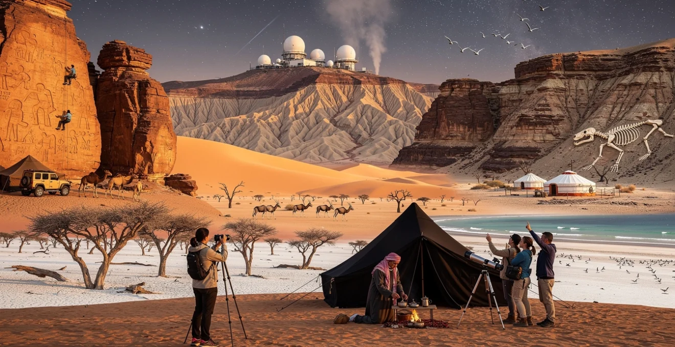
Wadi Rum, Jordan’s spectacular desert wilderness, presents a landscape so otherworldly that it has served as a filming location for multiple science fiction productions set on Mars. This protected area encompasses approximately 720 square kilometres of rust-red sandstone mountains, natural arches, and sweeping sand corridors that rise dramatically from the desert floor. The geological formations here represent millennia of wind and water erosion, creating towering cliffs that reach heights of 1,750 metres and narrow canyons that offer both visual spectacle and technical climbing challenges.
The region’s significance extends far beyond its cinematic qualities. Wadi Rum has been inhabited for thousands of years, with evidence of human presence dating back to prehistoric times. The Nabataean civilization, famous for constructing the ancient city of Petra, left their mark here through an extensive network of rock inscriptions, temples, and water management systems that demonstrate their sophisticated understanding of desert survival. Today, the area is home to several Bedouin tribes whose ancestors have navigated these landscapes for generations, maintaining traditional practices whilst engaging with modern tourism opportunities.
Lawrence of arabia film locations and petroglyphic rock art sites
The connection between Wadi Rum and T.E. Lawrence runs deeper than the famous 1962 film. Lawrence actually spent considerable time in the region during the Arab Revolt of 1916-1918, and his descriptions of the landscape in Seven Pillars of Wisdom remain remarkably evocative. Visitors can explore locations associated with his campaigns, including the spring at Ain Abu Aineh where Lawrence reportedly watered his camels. However, the human story here stretches back far beyond the 20th century.
Wadi Rum contains over 25,000 petroglyphs and 20,000 inscriptions scattered across its rock faces, representing various periods of human occupation. The earliest rock art dates to the Thamudic period (approximately 300 BCE to 300 CE) and depicts hunting scenes, human figures, and animals that once roamed the region, including ostriches and ibex. Later Nabataean inscriptions provide valuable insights into trade routes, religious practices, and daily life. The Khazali Canyon serves as an outdoor museum where you can observe particularly well-preserved examples of this ancient artwork, though access is carefully managed to prevent deterioration.
Bedouin cultural immersion through traditional goat hair tent hospitality
Authentic Bedouin hospitality remains central to the Wadi Rum experience, with several tribes offering overnight stays in traditional goat hair tents known as beit ash-sha’ar (house of hair). These accommodations, woven from black goat hair that naturally expands when wet to provide waterproofing, represent centuries of adaptation to desert conditions. The design allows hot air to escape through the loose weave whilst providing shade during the day, demonstrating ingenious environmental engineering long before modern climate control systems existed.
Staying with Bedouin families provides opportunities to participate in
preparing traditional Bedouin dishes, such as zarb (pit-cooked lamb and vegetables) and freshly baked flatbread. Evenings typically centre around a communal fire, where you can share sweet mint tea, listen to stories about tribal history, and hear poetry that has been passed down orally for generations. Many camps have adapted to modern expectations with solar-powered lighting and basic washroom facilities, yet still maintain low-impact practices that respect the fragile desert ecosystem. As a guest, you are encouraged to adopt these principles too, minimising water use and leaving no trace as you explore.
For travellers interested in genuine cultural immersion rather than staged performances, smaller, family-run camps in the protected area offer the most rewarding experiences. You might wake before dawn to join your hosts in tending camels, learn to grind coffee the traditional way, or help weave goat hair panels used to repair the tents. These seemingly simple tasks reveal a sophisticated knowledge system of desert navigation, animal husbandry, and resource management. By staying longer than a single night, you gain a more nuanced understanding of how Bedouin communities negotiate the balance between conservation, cultural continuity, and the economic opportunities that desert tourism provides.
Technical rock climbing routes on jebel rum and jebel umm ishrin
For adventure travellers and experienced climbers, Wadi Rum offers some of the most celebrated desert climbing in the world. The sandstone massifs of Jebel Rum and Jebel Umm Ishrin are etched with long, multi-pitch routes that combine traditional protection with sections of scrambling and exposed ridge walking. Grades range from moderate climbs suitable for fit trekkers with a head for heights to serious technical routes requiring advanced skills, route-finding experience, and self-rescue competence. The rock can be brittle in places, so careful movement and an understanding of sandstone ethics are essential.
Most visitors who want to sample Wadi Rum’s vertical terrain without taking on extreme risk choose guided ascents with local Bedouin climbers. These guides know the mountains intimately, often following historic hunting and herding paths that have been adapted into mountaineering routes. Classic objectives include the East Face of Jebel Rum and the traverse of Jebel Umm ad Dami, Jordan’s highest peak at 1,854 metres. Because temperatures can be intense in summer and the rock retains heat, the best seasons for climbing are generally March–May and October–November. Early starts, ample hydration, and respect for afternoon winds are non-negotiable safety considerations.
Astronomical tourism and dark sky reserve stargazing programmes
Once the sun sinks behind Wadi Rum’s jagged horizon, a different attraction takes centre stage: the night sky. Far from major urban centres, Wadi Rum benefits from exceptionally low light pollution, making it one of the best stargazing destinations in the Middle East. On clear, moonless nights, the Milky Way appears as a luminous river overhead, and constellations that may be faint at home stand out in sharp relief. Several camps now offer structured dark sky programmes, pairing basic astronomical explanations with high-quality telescopes and guided observation sessions.
These stargazing experiences often weave together modern science and traditional Bedouin sky lore. You might learn how nomads historically used specific stars to navigate trade routes or to time seasonal migrations, alongside explanations of planetary motion and deep-sky objects. Because Wadi Rum’s climate is generally dry, visibility is excellent for much of the year, though occasional dust or sandstorms can reduce clarity. To make the most of desert astronomy, plan your visit outside of full moon phases, bring warm layers for the sharp nighttime temperature drop, and allow your eyes at least 20 minutes to adapt to the dark. In a world where many of us rarely see more than a handful of stars, this unfiltered celestial panorama can be one of the most transformative aspects of desert travel.
Atacama desert’s astronomical observatories and pre-columbian archaeological complexes
Stretching along northern Chile between the Pacific Ocean and the Andes, the Atacama Desert is renowned both as the driest non-polar desert on Earth and as one of the world’s foremost hubs for astronomical research. Annual rainfall in some regions is so low that weather stations have never recorded measurable precipitation, creating conditions comparable to those on Mars. This hyper-aridity, combined with high altitude and minimal light pollution, has attracted major international observatories as well as travellers eager to experience the Atacama’s surreal landscapes and ancient cultural sites. You quickly realise that an Atacama itinerary can easily combine star-filled nights with days spent exploring salt flats, geothermal fields, and pre-Columbian archaeological complexes.
Despite its extreme environment, the Atacama has supported human life for thousands of years. Prehistoric communities developed ingenious water-harvesting systems, terraced agriculture, and ritual practices adapted to scarcity and altitude. Today, archaeological museums in towns such as San Pedro de Atacama provide context for field visits to nearby ruins, geoglyphs, and ancient cemeteries. Meanwhile, cutting-edge scientific projects like the Atacama Large Millimeter/submillimeter Array (ALMA) and the Very Large Telescope (VLT) at Paranal draw astrophysicists from around the globe—and increasingly, informed travellers interested in astronomical tourism.
ALMA radio telescope array and paranal observatory professional tours
ALMA, located on the Chajnantor Plateau at an elevation of 5,000 metres, is the world’s most powerful radio telescope for studying the cold universe—regions where stars and planets are born. The facility’s 66 high-precision antennas work together as an interferometer, effectively creating a telescope up to 16 kilometres across. While access to the high site is restricted due to altitude and operational requirements, ALMA’s operations support facility near San Pedro de Atacama offers limited public tours on specific days. These usually include an introductory talk, a visit to the control rooms, and an explanation of how radio astronomy complements optical observation.
Further south, the European Southern Observatory’s Paranal Observatory houses the VLT, a cluster of four 8.2-metre telescopes and several smaller instruments perched at 2,635 metres above sea level. Guided tours typically operate on weekends and must be reserved well in advance, reflecting strict security and safety protocols. Visitors can expect to tour the telescope domes, learn how adaptive optics correct atmospheric distortion, and understand why the Atacama’s clear, dry air gives it a competitive edge over many other sites worldwide. Because these are working scientific facilities, last-minute operational changes can affect access; building flexibility into your itinerary and monitoring official websites for updates is advisable.
Valle de la luna’s geological salt formations and moon valley ecosystems
Just a short drive from San Pedro, Valle de la Luna (Moon Valley) offers a compact showcase of the Atacama’s geological drama. Here, wind and water have sculpted salt, clay, and sandstone into ridges, craters, and jagged formations that genuinely resemble a lunar landscape. The valley lies within the Cordillera de la Sal, a ridge of folded strata where subterranean salt deposits have been pushed upwards and then eroded, leaving behind gleaming white crusts and intricate patterns. Walking trails and designated viewpoints allow you to observe polygonal salt flats, sharp fins of rock, and natural amphitheatres without damaging these delicate features.
Although the name suggests lifelessness, Moon Valley supports a surprising range of hardy organisms. Microscopic life forms persist in saline soils, and occasional fogs drifting inland from the Pacific provide just enough moisture for specialised lichens and small shrubs. Visiting in late afternoon allows you to watch the colours shift from ochre and copper to deep purple as the sun sets behind the Andes—a favourite moment for photographers. To protect this fragile environment, stay on marked paths, avoid removing salt crystals as souvenirs, and consider visiting with a licensed guide who can explain how these ecosystems function with almost no rainfall.
Geysers del tatio high-altitude geothermal field expeditions
At over 4,200 metres above sea level, Geysers del Tatio is one of the highest geothermal fields accessible to travellers. More than 80 active geysers and hundreds of fumaroles and hot springs dot a broad basin rimmed by volcanic peaks, creating an eerie landscape of steam plumes and bubbling pools. Most tours depart San Pedro before dawn, arriving in time to see the geysers at their most active in the cold early hours, when the contrast between scalding water and sub-zero air makes the steam columns rise dramatically. This combination of altitude and temperature can be demanding, so it is crucial to acclimatise gradually and drink plenty of water.
Because geothermal features can be unpredictable and dangerously hot, designated walkways and safety briefings are not optional formalities but essential protections. While some areas include thermal pools where bathing is permitted, entering only in marked zones helps prevent accidents and preserves delicate mineral formations. You may notice that the area’s geothermal potential has attracted interest in renewable energy development, raising complex questions about balancing local livelihoods, conservation, and national energy needs. As you explore, you become part of this broader conversation about how we value and manage desert landscapes that are rich in both natural wonder and economic potential.
Chinchorro mummies UNESCO sites and ancient funeral practices
Long before the rise of the Inca, the Chinchorro culture occupied parts of the Atacama’s coast, developing the world’s oldest known artificially mummified human remains. Some Chinchorro mummies date back to around 5000 BCE, predating Egypt’s earliest examples by nearly two millennia. Rather than preserving only elites, the Chinchorro appear to have mummified individuals across age and social lines, indicating a complex set of beliefs about community, death, and the afterlife. In 2021, UNESCO recognised several Chinchorro sites in and around Arica as World Heritage, highlighting their global significance.
Today, museums in Arica and nearby cities display select mummies and funerary artefacts under tightly controlled conditions to slow deterioration. Visiting these exhibitions with a knowledgeable guide helps you appreciate the technical sophistication behind the embalming methods, which included disarticulation, reconstruction with sticks and clay, and careful pigmentation. Field visits to associated archaeological zones are usually highly regulated to prevent looting and damage; always follow local guidelines and respect restricted areas. Confronting these remarkably preserved ancestors can be a powerful experience, prompting us to question how our own societies commemorate the dead and what material traces we will leave in our own extreme environments.
Namib desert’s endemic wildlife corridors and sossusvlei’s photographic opportunities
Formed at least 55 million years ago, the Namib is often cited as the world’s oldest desert, a coastal strip of dunes and gravel plains stretching over 2,000 kilometres along the Atlantic seaboard of Namibia, Angola, and South Africa. Its towering sand dunes—some exceeding 300 metres—shift and reform under the influence of strong trade winds, creating endlessly changing patterns of light and shadow. Yet beyond the iconic orange dunes of Sossusvlei, the Namib also supports intricate wildlife corridors where animals have adapted to survive on fog, sparse vegetation, and seasonal water flows. For photographers, conservationists, and desert enthusiasts alike, the Namib offers a compelling interplay of aesthetics and ecology.
Recent conservation initiatives have focused on maintaining connectivity between protected areas such as Namib-Naukluft National Park and community conservancies that border the desert. These corridors are critical for desert-adapted elephants, lions, and ungulates that roam widely in search of food and water. As visitor numbers increase, especially around popular dune fields, responsible tourism practices—limiting off-road driving, observing speed limits, and supporting conservancy-led lodges—play a key role in ensuring wildlife can continue to move freely across this harsh yet fragile landscape.
Deadvlei’s 900-year-old camel thorn trees and clay pan formation
Deadvlei, near Sossusvlei, is one of the most photographed sites in Namibia, and it is not hard to see why. A flat white clay pan, seared by the sun, is punctuated by the blackened trunks of camel thorn trees (Vachellia erioloba) that died approximately 600–900 years ago when shifting dunes cut off the Tsauchab River. With the water source gone, the trees dried out but did not decompose, preserved by the arid climate and intense solar radiation. The result is a stark tableau where skeletal trees stand against a backdrop of blazing red dunes and deep blue skies—an almost graphic, two-dimensional scene that feels more like a painting than reality.
Understanding how Deadvlei formed adds depth to its visual impact. During wetter climatic periods, the Tsauchab occasionally flooded, depositing silt and creating shallow pools where camel thorn trees could thrive. As climatic conditions shifted and dunes migrated, the river’s course was blocked, leaving behind an isolated basin that gradually desiccated. When you walk across the pan today, the clay beneath your feet bears minute cracks and patterns that speak to repeated cycles of wetting and drying long past. To capture the best images while minimising disturbance, visit at sunrise or late afternoon, stick to existing paths where possible, and avoid climbing on the ancient tree remains.
Sandwich harbour’s coastal dune systems and marine bird sanctuaries
Further north, near Walvis Bay, Sandwich Harbour presents a dramatic juxtaposition where immense dunes plunge directly into the Atlantic Ocean. This meeting of desert and sea creates a mosaic of habitats, including tidal flats, salt marshes, and ephemeral lagoons that serve as vital stopover points for migratory birds along the East Atlantic Flyway. Species such as greater flamingos, pelicans, and numerous waders can be observed feeding in nutrient-rich shallows while dune slopes behind them bear the tracks of beetles, geckos, and jackals. It is a reminder that even the most seemingly barren coastal desert can function as a biological hotspot.
Access to Sandwich Harbour typically requires a qualified 4×4 operator familiar with tides and shifting sands; self-driving without experience is risky due to the potential for vehicles to become trapped between incoming waves and dune faces. Responsible guides will adjust routes to avoid disturbing sensitive roosting areas, particularly during peak migratory seasons. As a visitor, you can support conservation by choosing operators that adhere to strict environmental guidelines, keep a respectful distance from wildlife, and participate in ongoing monitoring programmes. In many ways, the narrow strip of beach here functions like a living laboratory, illustrating how climate change and sea-level rise may influence both desert and marine ecosystems in years to come.
Welwitschia mirabilis botanical trails and desert-adapted flora studies
Among the Namib’s most remarkable inhabitants is Welwitschia mirabilis, a plant so unusual that it has its own taxonomic family. Often described as looking like a tangle of weathered ribbons, each Welwitschia produces only two leaves that grow continuously throughout its life, which can span 1,000–2,000 years. These leaves split and fray over time, giving older specimens a rugged, almost sculptural appearance. Specially designated Welwitschia trails, particularly in the northern Namib near Swakopmund, allow visitors to observe these living fossils from marked viewpoints without trampling their shallow root systems.
Scientists study Welwitschia and other desert-adapted flora to understand how plants cope with extreme heat, limited water, and high salinity—knowledge that may prove increasingly valuable as global climates warm. Welwitschia, for example, can absorb moisture from coastal fog and has developed efficient mechanisms to minimise water loss. When walking botanical routes, you will notice interpretive signage explaining these adaptations, but local guides can also provide insights into how Indigenous communities traditionally used certain species for food, medicine, or construction. Staying on designated tracks and resisting the temptation to collect seeds or cuttings is essential to preserving these slow-growing populations.
Skeleton coast shipwreck heritage and cape fur seal colonies
The Skeleton Coast, stretching from north of Swakopmund to Angola, has earned its ominous name from the remains of shipwrecks and whale carcasses that once littered its shores. Powerful currents, dense fog, and shifting sandbanks made these waters treacherous for sailors, and rusting hulls still protrude from beaches in haunting testament to past maritime disasters. Today, sections of the coast fall within national parks and concessions that regulate access, both to protect its fragile desert and marine environments and to ensure visitor safety. Limited-permit tourism has kept the area largely wild, reinforcing its reputation as one of the world’s last great coastal wildernesses.
Amid the wreckage and wind-sculpted dunes, life thrives in unexpected abundance. Vast colonies of Cape fur seals occupy offshore rocks and beaches, their numbers sometimes exceeding 200,000 at a single site. These colonies, in turn, attract predators such as brown hyenas and occasionally desert-adapted lions, creating a dynamic food web in an otherwise sparse setting. Visiting seal colonies can be an intense sensory experience due to noise and smell, but it offers a powerful illustration of how nutrient flows from the ocean sustain desert ecosystems. To minimise disturbance, maintain recommended distances, avoid sudden movements, and follow your guide’s instructions carefully.
Gobi desert’s dinosaur fossil sites and mongolian nomadic ger experiences
Covering large swathes of southern Mongolia and northern China, the Gobi Desert is a cold desert characterised more by stony plains and rugged outcrops than endless sand. Winter temperatures can plunge below –30°C, while summers bring dry heat and fierce winds. This challenging environment has preserved one of the world’s richest collections of dinosaur fossils and has shaped a resilient nomadic culture centred on mobile livestock herding. Travelling through the Gobi, you quickly sense that its story is as much about deep time and palaeontology as it is about contemporary life in felt-lined gers (yurts).
Many itineraries focus on the Mongolian side of the Gobi, where protected areas such as Gurvan Saikhan National Park encompass canyons, ice-filled gorges, and shifting dunes. Distances between sites are considerable, and infrastructure remains minimal outside major settlements, which is part of the region’s appeal for travellers seeking remoteness. At the same time, this remoteness demands careful logistical planning: reliable vehicles, experienced drivers, and flexible schedules are essential in a landscape where tracks can vanish with a sandstorm and fuel stops may be hundreds of kilometres apart.
The Flaming Cliffs of Bayanzag are among the Gobi’s most famous fossil sites, where American explorer Roy Chapman Andrews led expeditions in the 1920s and uncovered the first scientifically documented dinosaur eggs. The cliffs glow red at sunset, and erosion continues to reveal new bones and egg fragments, though strict regulations now govern collection and export. Guided visits focus on explaining the geology and palaeontological significance while reinforcing the importance of leaving any finds in situ. Elsewhere in the Gobi, ongoing digs—usually off-limits to casual visitors—continue to refine our understanding of Late Cretaceous ecosystems, offering a reminder that much of the region’s scientific potential is still unfolding.
Equally central to the Gobi experience is time spent with nomadic families in their gers. These round, collapsible dwellings can be dismantled and reassembled in a matter of hours, allowing herders to follow seasonal pastures with goats, sheep, camels, and horses. Staying in family-run ger camps, you might help collect dung fuel, sample salty milk tea and fermented mare’s milk, or ride Bactrian camels across nearby dunes. Hospitality customs are strong—guests are typically offered food and drink soon after arrival—yet expectations around behaviour are clear too: stepping on a ger’s threshold or refusing offered refreshments outright is considered impolite. Learning a few basic Mongolian phrases and following your host’s cues goes a long way toward building genuine connection.
As climate change and economic pressures reshape pastoral life, many Mongolian families now combine traditional herding with income from tourism. When you book through locally owned operators, pay fair rates for homestays, and avoid bargaining excessively over already modest prices, you help sustain this mixed livelihood strategy. In return, you gain insight into how nomadic societies are adapting to new realities while maintaining core values of mobility, mutual aid, and respect for the land—a perspective that can challenge more sedentary assumptions about what a “desert lifestyle” looks like.
White desert national park’s chalk rock formations and saharan oasis communities
In Egypt’s Western Desert, roughly 500 kilometres southwest of Cairo, White Desert National Park (El Sahara El Bayda) presents a landscape that seems almost extraterrestrial. Here, wind and occasional sandstorms have sculpted ancient marine chalk deposits into surreal formations that resemble mushrooms, towers, and abstract sculptures scattered across a pale, powdery plain. These chalk outcrops are remnants of a time when this region lay beneath a shallow sea, and fossilised shells embedded in the rock still testify to its marine origins. Under the shifting light of sunrise, sunset, and moonrise, the formations change character, offering photographers an endlessly varied set of compositions.
Most visitors access the White Desert via the Bahariya or Farafra oases, using 4×4 vehicles and licensed desert guides who understand local routes, regulations, and weather patterns. Overnight camping inside the park is one of the most sought-after experiences, with simple campsites set among the chalk pillars. Without light pollution, the sky becomes a brilliant dome of stars, and the white rock reflects moonlight so intensely that on full-moon nights, you can often walk without a torch. As in other desert environments, strict leave-no-trace practices are essential: packing out all rubbish, minimising campfire impacts, and staying within designated camping areas help ensure that this fragile chalk landscape remains unspoiled.
The nearby Black Desert provides a striking contrast, its hills and dunes dusted with dark volcanic rocks that give the terrain a charred appearance. Day trips often combine both the White and Black Deserts, revealing the geological diversity of Egypt’s interior. Along the way, you may encounter hot springs used by locals for bathing and irrigation, remnants of Roman-era settlements, and lookout points that illustrate how erosion has carved mesas and plateaus over millions of years. If you have ever wondered how many different “colours of desert” one region can contain, this area offers an eloquent answer.
Equally important to the region’s character are the oasis communities that dot the landscape, particularly in Bahariya and Farafra. These settlements rely on groundwater accessed through wells and springs, supporting date palms, olive groves, and small-scale agriculture in otherwise barren surroundings. Traditional mud-brick architecture helps moderate temperature extremes, while narrow alleyways and courtyards foster social cohesion and privacy. With the growth of desert tourism, some families have opened guesthouses and small lodges, offering home-cooked meals, handicrafts, and guiding services. By choosing to stay in locally owned accommodation and purchasing dates, pottery, or woven goods directly from artisans, you contribute to an economy that encourages the preservation of oasis culture rather than its replacement by generic resort models.
Water scarcity and changing rainfall patterns pose long-term challenges for these communities, making sustainable tourism practices more than just a marketing term. Conserving water during your stay, respecting local norms around dress and photography, and listening to residents’ perspectives on how tourism affects their lives all help ensure that your visit is mutually beneficial. In this way, the White Desert becomes more than a backdrop for striking images; it becomes a context in which to reflect on resilience, adaptation, and the human capacity to create flourishing communities in the most unlikely places.
Thar desert’s rajasthani fortress architecture and indigenous bishnoi conservation practices
Straddling the border between India and Pakistan, the Thar Desert—often called the Great Indian Desert—is one of the world’s most densely populated arid regions. Unlike many deserts where human presence is sparse, the Thar is dotted with villages, farms, and historic towns that have thrived for centuries despite erratic rainfall and frequent droughts. This concentration of people has given rise to a rich cultural landscape of music, craft, and architecture, especially in the Indian state of Rajasthan. At the same time, the region is home to distinctive conservation traditions, most notably among the Bishnoi community, whose environmental ethics predate many modern sustainability frameworks.
Rising from the sands near the Indo-Pak border, Jaisalmer is perhaps the Thar’s most iconic urban centre. Its sandstone fort, a UNESCO World Heritage Site, appears to grow organically out of the desert, its golden walls and intricately carved havelis (mansions) gleaming in the sun. Within the fort’s walls, narrow lanes wind past Jain temples, rooftop cafés, and family homes, creating a living citadel rather than a preserved ruin. Careful urban management is increasingly important here, as water demand, waste disposal, and modern construction put pressure on a delicate hilltop environment. As a visitor, opting for accommodations that support heritage conservation, using refillable water bottles, and minimising single-use plastics can help reduce your footprint in this concentrated space.
Beyond Jaisalmer, smaller desert towns and caravanserai along historic trade routes contain their own architectural treasures: stepwells engineered to capture and store precious rainwater, fortified farmsteads designed to withstand both raids and sandstorms, and painted courtyard houses adorned with scenes from mythology and daily life. Exploring these structures with a local guide reveals how Rajasthani builders integrated climate-responsive design long before air conditioning existed—using thick walls, internal courtyards, and jali (lattice) screens to create ventilation and shade. For travellers interested in sustainable architecture, the Thar can feel like an open-air design school.
Interwoven with this built heritage are the practices of the Bishnoi, a Hindu sect founded in the 15th century by Guru Jambheshwar, who articulated 29 principles (from which the community’s name derives) that include strict protections for trees and animals. Bishnoi people are perhaps best known internationally for the 1730 Khejarli massacre, in which more than 300 villagers reportedly sacrificed their lives while trying to prevent the felling of sacred khejri trees by royal loggers. This event has become a powerful symbol of early environmental activism and continues to inform Bishnoi identity today.
Modern Bishnoi communities in Rajasthan still enforce taboos against cutting green trees and hunting wildlife, leading to pockets of unexpectedly rich biodiversity within the broader agricultural landscape. Antelopes such as blackbuck and chinkara often graze near villages with little fear, and Bishnoi households routinely provide water and fodder during dry periods. Some villages have begun hosting visitors interested in learning about these conservation traditions, offering jeep safaris to observe wildlife, demonstrations of local crafts, and discussions about how spiritual beliefs translate into everyday environmental practice. When you participate in such visits respectfully—dressing modestly, asking permission before photographs, and avoiding intrusive questioning—you support a model of tourism that values knowledge exchange as much as spectacle.
The Thar Desert’s combination of fortress towns, living religious landscapes, and community-led conservation challenges the notion that deserts are empty or ecologically marginal. Instead, it reveals how dense human settlement and biodiversity can coexist when guided by long-standing cultural norms and pragmatic adaptation. As we look to the future of desert destinations worldwide, the lessons embedded in Rajasthani water harvesting, Bishnoi ethics, and fortress urbanism may prove as valuable as any natural resource, offering frameworks for resilience in an era of accelerating environmental change.