Northern landscapes represent some of Earth’s most spectacular natural formations, where ancient geological processes have carved extraordinary terrain that captivates photographers, adventurers, and nature enthusiasts alike. These regions showcase the planet’s raw power through dramatic fjords carved by glacial action, vast arctic tundra shaped by permafrost dynamics, and towering coastal cliffs sculpted by relentless marine erosion. From Scandinavia’s breathtaking fjord systems to the pristine wilderness of the Canadian Arctic, northern territories offer unparalleled scenic beauty that reveals the intricate relationship between climate, geology, and time.
The appeal of northern scenic destinations extends far beyond their visual impact. These landscapes serve as living laboratories where visitors can witness ongoing geological processes, observe unique atmospheric phenomena like the aurora borealis, and experience ecosystems that have adapted to extreme conditions. The combination of accessibility and wilderness creates opportunities for both casual tourists and serious expedition travellers to engage with some of the world’s most pristine natural environments.
Scandinavian fjord systems: geological formations and visual impact
Scandinavian fjords represent the pinnacle of glacial landscape architecture, where massive ice sheets carved deep valleys that now contain some of the world’s most spectacular waterways. These geological masterpieces demonstrate the incredible erosive power of glacial action over millions of years, creating narrow waterways flanked by vertical rock faces that tower hundreds of metres above sea level. The visual drama of these formations lies in their scale and the stark contrast between the dark, reflective waters and the light-coloured granite and gneiss cliff faces.
The formation process of these fjords involved repeated glacial advances and retreats during multiple ice ages, with the most recent glacial period ending approximately 10,000 years ago. As glaciers moved through pre-existing river valleys, they deepened and widened them through a combination of plucking and abrasion, creating the characteristic U-shaped profile that defines fjord topography. The result is a landscape where water depths can exceed 1,000 metres, creating an almost surreal sense of scale that photographs struggle to capture adequately.
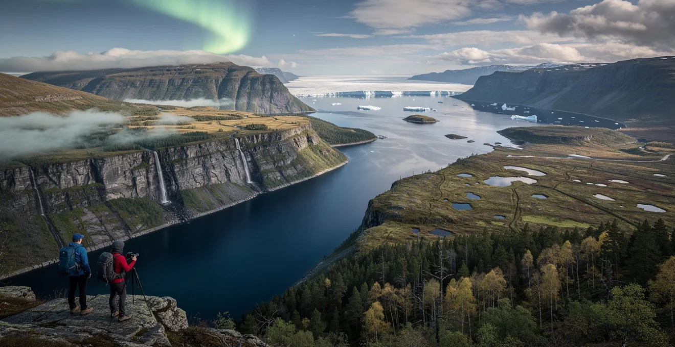
Geirangerfjord’s UNESCO world heritage glacial carving patterns
Geirangerfjord stands as one of Norway’s most celebrated natural monuments, earning UNESCO World Heritage status due to its exceptional demonstration of glacial landscape formation. The fjord extends 15 kilometres inland from the Sunnylven fjord, creating a narrow corridor flanked by peaks reaching 1,700 metres above sea level. The geometric precision of its glacial carving becomes evident in the steep valley walls that maintain consistent angles throughout their length, reflecting the uniform erosive action of the ice sheet that formed them.
The fjord’s most distinctive features include the Seven Sisters waterfall, where seven separate streams cascade down the cliff face in a display that varies dramatically with seasonal water levels. These waterfalls demonstrate how glacial carving created hanging valleys—tributary valleys that were not carved as deeply as the main fjord, leaving them suspended above the current water level. The interplay between these vertical water features and the horizontal expanse of the fjord creates a dynamic visual composition that changes throughout the day as light conditions shift.
Nærøyfjord’s narrow valley configuration and vertical rock faces
Nærøyfjord represents the extreme end of glacial valley narrowing, with some sections measuring only 250 metres across while maintaining depths of over 500 metres. This extraordinary width-to-depth ratio creates an almost canyon-like atmosphere where the sky appears as a narrow strip between towering walls. The psychological impact of this configuration cannot be understated—visitors often report feeling dwarfed by the sheer scale of the surrounding geology.
The rock faces of Nærøyfjord display exceptional geological diversity, with exposed layers revealing the complex tectonic history of the Scandinavian Peninsula. Precambrian gneiss formations dominate the lower elevations, while younger granite intrusions create distinct colour variations in the upper cliff sections. These geological variations become particularly pronounced during golden hour lighting, when the different rock types reflect light at varying intensities, creating a natural chiaroscuro effect that enhances the fjord’s dramatic visual appeal.
Sognefjord’s deep water
basin and tributary networks exemplify the maximum erosive capacity of Pleistocene ice. Often called the “King of the Fjords,” Sognefjord reaches depths of more than 1,300 metres while extending over 200 kilometres inland from the North Sea, with numerous side arms like Aurlandsfjord and Nærøyfjord branching off its main channel. This immense depth means cruise ships appear miniature against the vertical relief, highlighting just how profoundly glaciers re‑sculpted the original river valleys.
From a visual perspective, Sognefjord’s many tributary fjords create constantly shifting compositions as you move through the system. One moment you are enclosed by steep rock walls; the next, the landscape opens into wider basins framed by snow‑covered summits. For travellers interested in understanding fjord geomorphology, basing yourself in villages such as Flåm or Balestrand allows you to explore different branches by ferry, kayak, or scenic road, each revealing another facet of this complex glacial network.
Hardangerfjord’s plateau integration and seasonal waterfall cascades
Hardangerfjord offers a contrasting fjord experience where high plateaus merge seamlessly with deeply incised valleys. Here, the Hardangervidda plateau—Northern Europe’s largest mountain plateau—feeds countless meltwater streams that plunge abruptly into the fjord below. This plateau-fjord integration produces a landscape where broad, relatively gentle uplands terminate in sheer cliffs, creating a striking edge effect visible from both the water and the surrounding hiking trails.
Hardangerfjord is particularly renowned for its seasonal waterfall cascades, which peak during late spring and early summer snowmelt. Iconic falls such as Vøringsfossen demonstrate how rivers have cut narrow gorges through the plateau margin before dropping more than 150 metres into the valley floor. For photographers seeking dramatic northern landscapes worth visiting, this region rewards flexible timing: visiting in May or June maximises waterfall volume, while autumn brings intense foliage colour that contrasts with the grey rock and deep blue water.
Arctic tundra landscapes: permafrost topography and atmospheric phenomena
Moving north from the fjord country, Arctic tundra landscapes present an entirely different type of dramatic scenery. Instead of steep rock walls and deep water, you encounter vast open spaces where permafrost controls both surface patterns and vegetation. These environments may appear barren at first glance, yet a closer look reveals intricate ground textures, subtle elevation changes, and a surprising diversity of colours, especially during the brief Arctic summer.
Permafrost—ground that remains frozen for at least two consecutive years—acts like a hidden architect, shaping everything from polygonal ground to thaw lakes and ice wedges. Combined with some of the clearest air on Earth and unique atmospheric phenomena such as the midnight sun and aurora borealis, these northern regions offer some of the most otherworldly vistas you can experience. For travellers prepared to contend with extreme temperatures and remote logistics, the reward is access to landscapes that feel closer to another planet than to more temperate destinations.
Svalbard’s polar desert terrain and midnight sun photography conditions
Svalbard, an archipelago midway between mainland Norway and the North Pole, showcases classic polar desert terrain: sparse vegetation, bare rock, and extensive ice caps broken by deep fjords. Here, precipitation levels are low, so glaciers and snowfields are maintained primarily by cold rather than abundant snowfall. The result is a stark, high-contrast landscape where dark mountains rise sharply from ice-filled bays, and broad glacial valleys cut inland like frozen rivers.
From a visual standpoint, Svalbard is particularly compelling during the midnight sun period from late April to late August. Continuous low-angle sunlight bathes the terrain in soft, golden tones for hours at a time, ideal for long-exposure photography and expansive panoramas. Because the sun never fully sets, you can experiment with different vantage points well past “normal” shooting hours; many photographers plan their main outings between 22:00 and 03:00, when the light is warmest and wildlife activity often increases along the coast.
Finnish lapland’s fell mountain formations and aurora borealis visibility
Finnish Lapland offers a gentler Arctic landscape where rounded fells—low, dome-shaped mountains—rise above boreal forest and wetland mosaics. These fells are remnants of ancient mountain ranges heavily eroded over hundreds of millions of years, leaving behind smooth summits that provide open 360‑degree views. In winter, when snow smooths remaining surface irregularities, the landscape becomes almost minimalistic, with clean lines and soft ridges stretching towards the horizon.
This subdued topography actually enhances Aurora Borealis visibility. With limited tall vegetation and broad, open skies, you can often see northern lights displays from any slightly elevated hilltop near lodges and villages such as Saariselkä, Levi, or Kilpisjärvi. For the best chance of witnessing intense auroral activity, plan at least three to five nights between September and March, monitor real-time aurora forecasts, and stay flexible: some of the most dramatic shows begin just when many visitors are thinking of going to sleep.
Greenland’s ice sheet calving zones and glacial lake systems
Greenland’s ice sheet, covering roughly 80% of the island, generates some of the most powerful visual experiences in any northern landscape. Along the west coast, huge outlet glaciers flow from the ice sheet towards the sea, terminating in towering calving fronts where blocks of ice the size of buildings break off and crash into the water. Places like Ilulissat Icefjord, another UNESCO World Heritage site, allow you to observe this process from marked viewpoints or boat excursions among drifting icebergs.
In summer, surface meltwater forms vivid blue supraglacial lakes and meltwater channels on top of the ice sheet, creating patterns that look almost abstract from the air. These lakes often drain suddenly through crevasses and moulins, delivering torrents of water to the glacier base and accelerating ice flow. For travellers, helicopter or small-plane flights offer the safest and most informative way to appreciate this dynamic environment, combining sweeping views with expert commentary on how climate change is altering Greenland’s cryosphere in real time.
Canadian arctic archipelago’s polygonal ground patterns and thermal erosion
The Canadian Arctic Archipelago, stretching across the high latitudes of Nunavut and the Northwest Territories, presents one of the best natural laboratories for observing polygonal ground patterns created by permafrost dynamics. As the active layer above permafrost repeatedly freezes and thaws, it contracts and fractures, forming networks of cracks that fill with ice or sediment. Over centuries, these processes produce distinctive geometric shapes—often hexagonal or pentagonal—that are clearly visible from low-flying aircraft or drone imagery.
Thermal erosion is also prominently displayed along riverbanks and coastal bluffs, where warming temperatures destabilise ice-rich sediments. Sections of shoreline can slump dramatically as ground ice melts, leaving exposed blocks and fresh scarps that contrast with older, weathered slopes. Travellers joining expedition cruises or community-based tours in regions like Somerset Island or Banks Island can often see these features during guided hikes, gaining first-hand insight into how subtle temperature shifts are reshaping Arctic terrain.
Highland plateau systems: volcanic origins and weather pattern dynamics
Highland plateau systems in northern regions combine elevated topography with relatively flat or gently rolling surfaces, creating vast open spaces that feel dramatically different from both fjord country and coastal lowlands. Many of these plateaus have volcanic origins, with layers of basalt or other lava flows stacking up over time. Subsequent glaciation smoothed these surfaces, leaving behind broad uplands punctuated by isolated peaks and deeply incised river gorges.
The visual impact of these plateaus is amplified by their interaction with regional weather patterns. Westerly winds often rise over the high ground, cooling and condensing into cloud banks that cling to the plateau edges or spill into adjoining valleys. On days when conditions change rapidly, you might watch entire landscapes appear and disappear behind moving curtains of mist, a reminder that in northern landscapes worth visiting, atmosphere can be just as dramatic as geology. Practical considerations here include packing layered clothing, as temperatures and visibility can shift within minutes, especially in shoulder seasons.
Coastal cliff formations: marine erosion processes and sedimentary structures
Northern coastlines are prime locations for studying how waves, tides, and currents sculpt rock over geological timescales. Steep cliffs composed of sedimentary strata, volcanic flows, or metamorphic complexes rise directly from the sea, offering textbook examples of marine erosion processes. Features such as sea stacks, arches, and wave-cut platforms demonstrate how even the hardest rock yields to relentless mechanical and chemical weathering.
For visitors, these coastal cliff formations deliver some of the most immediate and visceral scenic experiences. Standing at the edge of a headland while Atlantic swells crash far below, you can often trace individual bedding planes, fault lines, and erosional notches along the rock face. Locations like the cliffs of northern Iceland, the Faroe Islands, or Norway’s Nordkapp combine vertical relief with sweeping ocean vistas, making them ideal for anyone interested in both geology and seascape photography. Safety is critical in such environments: strong winds, undercut edges, and rapidly changing weather demand caution and respect for marked paths and local guidance.
Boreal forest transition zones: ecotone characteristics and seasonal transformations
Between the open tundra and the denser temperate forests to the south lies a broad transition belt where ecosystems overlap and intermingle. These boreal forest ecotones are particularly rich in visual and ecological diversity, as species from both neighbouring biomes coexist and compete. Subtle changes in soil, moisture, and microclimate over just a few kilometres can produce noticeable shifts in vegetation structure, from low shrubs and scattered trees to continuous closed-canopy forest.
Seasonality adds another layer of drama to these northern landscapes worth visiting. In spring and summer, long daylight hours trigger rapid plant growth, filling the forest floor with wildflowers and fresh undergrowth. By autumn, deciduous components of the boreal mix—birch, aspen, larch—turn brilliant shades of yellow and orange, standing out against the dark greens of spruce and pine. Visitors who time their trips to coincide with these transitions are rewarded with scenes that rival any alpine or coastal destination in terms of colour and atmosphere.
Taiga-tundra boundary vegetation gradients in northern canada
In Northern Canada, particularly across Yukon, the Northwest Territories, and Nunavut’s southern margins, the taiga-tundra boundary forms a wide, undulating frontier between forest and open ground. Here, scattered black spruce and tamarack trees gradually give way to dwarf shrubs, sedges, and lichens as you move north or climb to higher elevations. The resulting gradient is rarely a sharp line; instead, it appears as a mosaic of forest patches, shrublands, and peat-rich wetlands that shift with local topography and drainage.
From a traveller’s perspective, this zone is fascinating because you can often observe multiple ecological communities within a single hike or canoe journey. Wildlife viewing opportunities are excellent as well: caribou, moose, and migratory birds use these transition areas as feeding grounds and movement corridors. If you are planning a photography-focused trip, consider late August or early September, when the tundra vegetation turns rich shades of red and gold while the last remaining conifers keep their deep green colour, creating strong visual contrast along the horizon.
Scandinavian coniferous forest canopy architecture
In Scandinavia, boreal coniferous forests cloak large portions of Norway, Sweden, and Finland, forming a distinctive canopy architecture shaped by cold climates and long winters. Dominated by species such as Norway spruce and Scots pine, these forests often develop a relatively simple vertical structure: a dense overstory with limited understorey in shaded areas, punctuated by patches of birch and aspen where disturbance has opened the canopy. On gently rolling terrain, this produces sweeping waves of dark green that seem to flow across hills and valleys.
Yet, when you walk through these forests, the experience is more nuanced than the aerial view suggests. Moss carpets, lichen-draped branches, and scattered boulders left by retreating glaciers create a textured ground layer that absorbs sound and light, lending a cathedral-like quality to the interior. For visitors, one of the best ways to appreciate this canopy architecture is to combine short hikes with viewpoints on adjacent fells or ridges; from above, you can see how lakes, wetlands, and rock outcrops break up the forest matrix into a complex patchwork.
Siberian larch woodland fire regeneration cycles
Siberian larch woodlands, stretching thousands of kilometres across northern Russia, illustrate how disturbance—in this case, fire—can be an integral part of boreal forest dynamics. Unlike many evergreen conifers, larch trees are deciduous, shedding their needles each autumn and turning entire hillsides a luminous gold before winter. These trees are well adapted to periodic wildfires, with thick bark and a regeneration strategy that takes advantage of nutrient-rich ash beds and increased sunlight after a burn.
For observers travelling along routes such as the Lena or Yenisei rivers, it is common to see different stages of this fire regeneration cycle within the same vista: charred trunks in recently burned stands, vigorously regenerating saplings in mid-successional patches, and mature larch forests that have not burned for decades. This mosaic creates a dynamic, layered landscape that tells a clear story of disturbance and recovery. While independent travel in much of Siberia remains logistically challenging, guided scientific or cultural expeditions can provide rare opportunities to witness these large-scale processes in person.
Alaska’s spruce-birch mixed forest succession patterns
In Alaska, mixed forests of white spruce, black spruce, and paper birch offer another perspective on boreal succession. Disturbances such as fire, insect outbreaks, and permafrost thaw often favour fast-growing birch and aspen in the early years, creating light, airy stands with high wildlife activity. Over time, shade-tolerant spruce seedlings establish beneath this pioneer canopy, gradually shifting the forest towards a conifer-dominated state unless another disturbance resets the cycle.
Travelling along the road corridors between Anchorage, Fairbanks, and the Interior, you can easily see these patterns in action. Young birch stands with smooth, pale trunks typically indicate recent disturbance, while darker, denser spruce forests often mark older, more stable sites. For those interested in both ecology and scenery, late September is a particularly rewarding time to visit: birch and aspen reach peak autumn colour just as the first snow dusts higher elevations, and clear nights increase your chances of seeing the aurora dancing above the evolving forest below.