The Earth’s volcanic regions offer some of the most spectacular and challenging landscapes for adventurous travellers seeking extraordinary experiences. From the steaming fumaroles of Iceland’s highland wilderness to the azure crater lakes of Indonesia’s Ring of Fire, volcanic terrain presents unique opportunities for exploration that combine geological wonder with heart-pounding adventure. These dynamic landscapes, shaped by millennia of eruptions and tectonic activity, create environments where visitors can witness the planet’s raw creative forces in action.
Volcanic tourism has evolved from simple sightseeing to sophisticated adventure expeditions that require specialised equipment, expert guidance, and comprehensive safety protocols. Modern adventurers can now access previously unreachable volcanic features through helicopter transfers, technical climbing routes, and multi-day wilderness expeditions. The growing popularity of volcano tourism has led to the development of specialised tour operators, advanced monitoring systems, and innovative access methods that balance safety with the desire for authentic wilderness experiences.
Iceland’s volcanic wonderlands: from eyjafjallajökull to landmannalaugar
Iceland’s position along the Mid-Atlantic Ridge creates one of the world’s most accessible volcanic landscapes, where visitors can experience active geothermal features, glacier-capped volcanoes, and otherworldly terrain sculpted by ice and fire. The island’s volcanic systems have produced some of the most dramatic eruptions in recorded history, yet they remain surprisingly accessible to adventurous travellers willing to venture beyond conventional tourist routes.
Eyjafjallajökull glacier volcano: trekking routes and safety protocols
The infamous Eyjafjallajökull volcano, which disrupted global air travel in 2010, offers challenging trekking opportunities across its glacier-covered summit and surrounding valleys. The standard approach route begins from the Þórsmörk valley, requiring river crossings and navigation across unstable volcanic terrain. Trekkers must carry glacier travel equipment including ropes, ice axes, and avalanche beacons when approaching the summit icecap during winter months.
Safety protocols for Eyjafjallajökull expeditions require comprehensive weather monitoring, as conditions can deteriorate rapidly at elevation. The Icelandic Met Office provides real-time volcanic activity updates, while local rescue teams maintain emergency communication systems throughout the region. Guided expeditions typically operate from June through September, when glacier conditions are most stable and rescue access is feasible.
Landmannalaugar rhyolite mountains: Multi-Day hiking expeditions
The Landmannalaugar region showcases Iceland’s most colourful volcanic landscapes, where rhyolite mountains display vivid reds, yellows, and greens created by mineral deposits from geothermal activity. The famous Laugavegur trail traverses this volcanic wonderland over four to six days, passing through geothermal fields, obsidian lava flows, and glacial valleys carved by volcanic activity.
Multi-day expeditions require careful planning due to rapidly changing weather conditions and limited shelter options. Mountain huts provide basic accommodation along established routes, but wild camping is necessary for off-trail exploration. The region’s geothermal features create unique camping challenges, as ground temperatures can vary dramatically within short distances, requiring specialised volcanic terrain camping techniques.
Westman islands volcanic archipelago: sea kayaking and cliff climbing
The Westman Islands offer unique opportunities to explore volcanic landscapes from both sea and cliff perspectives. The 1973 eruption of Eldfell volcano created dramatic new topography, while ongoing geological activity continues to shape the archipelago’s coastline. Sea kayaking expeditions navigate between towering volcanic cliffs and hidden sea caves carved by ancient lava flows.
Cliff climbing on the islands presents technical challenges due to the friable nature of young volcanic rock. Climbing routes require careful anchor placement and route selection, as recent volcanic activity has created unstable rock formations. Professional guides familiar with local geology are essential for safe exploration, particularly when accessing areas affected by recent eruptions.
Askja caldera complex: remote highland access and camping regulations
The Askja caldera complex in Iceland’s central highlands represents one of Europe’s most remote volcanic destinations, accessible
The Askja caldera complex in Iceland’s central highlands represents one of Europe’s most remote volcanic destinations, accessible only via rugged F-roads that are typically open from late June to early September. High-clearance 4×4 vehicles are mandatory, and travellers must be prepared for river crossings, loose ash surfaces, and sudden weather changes that can reduce visibility to just a few metres. Camping regulations within the Vatnajökull National Park are strict: overnight stays are generally limited to designated huts and marked camping areas to protect the fragile volcanic ecosystem. Due to the region’s isolation, visitors are advised to carry satellite communication devices, detailed topographic maps, and sufficient emergency supplies for at least 24–48 hours beyond their planned itinerary.
Bathing in the geothermal Víti crater lake has become a popular activity but comes with specific safety considerations and environmental guidelines. Water temperatures can vary significantly with depth, and unstable slopes mean that access points can change from season to season. Park authorities regularly update access recommendations, and you should always check current conditions before attempting any descent into the crater. Given the distance from rescue services and the lack of mobile coverage across much of the highlands, self-reliance and conservative decision-making are essential components of any Askja expedition.
Indonesia’s ring of fire: java and sumatra volcanic expeditions
Indonesia sits at the heart of the Pacific Ring of Fire, where converging tectonic plates generate some of the world’s most active and visually striking volcanoes. Java and Sumatra in particular offer a dense concentration of accessible volcanic landscapes, from ash-filled calderas to sulphur-rich crater lakes. Adventure travellers can combine sunrise summit treks with cultural immersion in highland villages that have adapted to life on volcanic slopes for centuries. With over 120 active volcanoes across the country, careful route selection and reliance on reputable local operators are crucial for safe and rewarding expeditions.
Modern volcano tourism in Indonesia blends traditional knowledge with advanced monitoring systems operated by the Centre for Volcanology and Geological Hazard Mitigation (CVGHM). Real-time seismic data, gas emission measurements, and visual observations inform access restrictions that can change at short notice. For travellers, this means flexibility is key: an active volcano trekking itinerary should always include backup options and an understanding that the safest decision may sometimes be to turn back. When approached with respect for local regulations and volcanic hazards, Indonesia’s Ring of Fire delivers some of the most memorable adventure travel experiences in the world.
Mount bromo tengger massif: sunrise photography and horseback tours
Mount Bromo, part of the wider Tengger Massif in East Java, is renowned for its ethereal sunrise views over a vast volcanic sand sea. Most visitors begin their ascent in the early hours of the morning, travelling by jeep or motorbike to viewpoints such as Mount Penanjakan before hiking or riding on horseback across the Sea of Sand. For landscape photographers, the pre-dawn mist, drifting volcanic smoke, and layered silhouettes of neighbouring peaks provide a rare combination of depth and contrast. Long-exposure techniques can capture the subtle colour shifts as the first light reveals the full scale of the caldera.
Despite Bromo’s reputation as a relatively accessible active volcano, safety protocols remain important. Eruption alerts and exclusion zones are enforced by local authorities, and access to the crater rim may be restricted during elevated activity. Visitors should avoid standing directly downwind of the crater, where sulphur-rich gases can accumulate and cause respiratory irritation. Horseback tours across the ash plain offer a lower-impact way to traverse the loose volcanic surface, but it is still advisable to wear dust masks and protective eyewear, particularly during the dry season when fine ash is easily lifted by the wind.
Kawah ijen crater lake: blue fire phenomena and sulphur mining encounters
Kawah Ijen, located in East Java, has become famous for its otherworldly blue fire phenomena—electric-blue flames caused by burning sulphuric gases that are best observed in the pre-dawn hours. To witness this spectacle, hikers typically begin their ascent around midnight, following a steep trail to the crater rim before descending along a narrow, rocky path toward the acidic crater lake. The lake itself is one of the most acidic bodies of water on Earth, its vivid turquoise colour created by high concentrations of dissolved metals and sulphur compounds. Visiting Kawah Ijen therefore demands strict adherence to safety guidelines for both gas exposure and footing on unstable terrain.
The crater is also an active sulphur mining site, where miners manually extract solid sulphur and carry heavy loads up the crater walls. Responsible visitors maintain a respectful distance, avoid obstructing work routes, and refrain from intrusive photography. Gas masks or at least high-quality respirators are strongly recommended, as wind shifts can rapidly direct dense sulphur fumes across the path. Headlamps with spare batteries, sturdy footwear, and layered clothing are essential for this night hike, which combines high-altitude exertion with potentially harsh volcanic conditions. While the blue fire is a key attraction, the combination of industrial activity, hazardous gases, and precipitous paths means that Kawah Ijen should always be approached with a certified local guide.
Mount merapi active volcano: guided jeep tours and evacuation routes
Mount Merapi, rising above the city of Yogyakarta in Central Java, is one of Indonesia’s most active and closely monitored volcanoes. Instead of summit attempts—which are often restricted due to ongoing activity—most adventure travellers explore Merapi via guided jeep tours that navigate hardened lava flows, ash fields, and abandoned villages impacted by past eruptions. These off-road routes provide insight into lahar channels, pyroclastic flow paths, and the sheer destructive power of recent eruptions, while still keeping visitors within established safety zones. You can expect frequent stops at viewpoints, small museums, and local memorials that document Merapi’s volcanic history.
Given Merapi’s unpredictable behaviour, evacuation routes and contingency plans are central to any responsible tour. Villages around the volcano conduct regular evacuation drills, and warning sirens are linked to the national monitoring network. Travellers should familiarise themselves with basic volcanic hazard terminology—such as exclusion zone and alert level—and always follow the instructions of local guides, who are trained in emergency response procedures. It is also wise to carry a lightweight mask or buff to protect against ash inhalation if activity levels increase unexpectedly. Merapi offers an exceptional case study in how communities live with an active volcano, and joining a regulated jeep tour is one of the safest ways to experience this dynamic landscape.
Lake toba supervolcano caldera: traditional batak village immersion
Lake Toba in Sumatra occupies the caldera of one of Earth’s largest known supervolcanoes, formed by a cataclysmic eruption approximately 74,000 years ago. Today, the caldera hosts a vast freshwater lake and Samosir Island, where visitors can explore rolling volcanic hills rather than active craters. Adventure here is more about long-distance trekking, lakeside cycling, and cultural immersion than technical climbing. Trails around Samosir offer panoramic views of the caldera walls, giving a sense of the immense scale of the ancient eruption that reshaped this region.
Staying in traditional Batak villages allows travellers to connect with local culture that has developed on the shores of a dormant volcanic giant. You can participate in community-led hikes, learn about indigenous agricultural practices on fertile volcanic soils, and attend performances of Batak music and dance. While Lake Toba does not pose the same immediate hazards as Indonesia’s active peaks, basic safety considerations still apply: weather can change quickly, and remote trails may be poorly marked. Hiring local guides not only supports community-based tourism but also ensures you navigate the caldera landscape efficiently and responsibly.
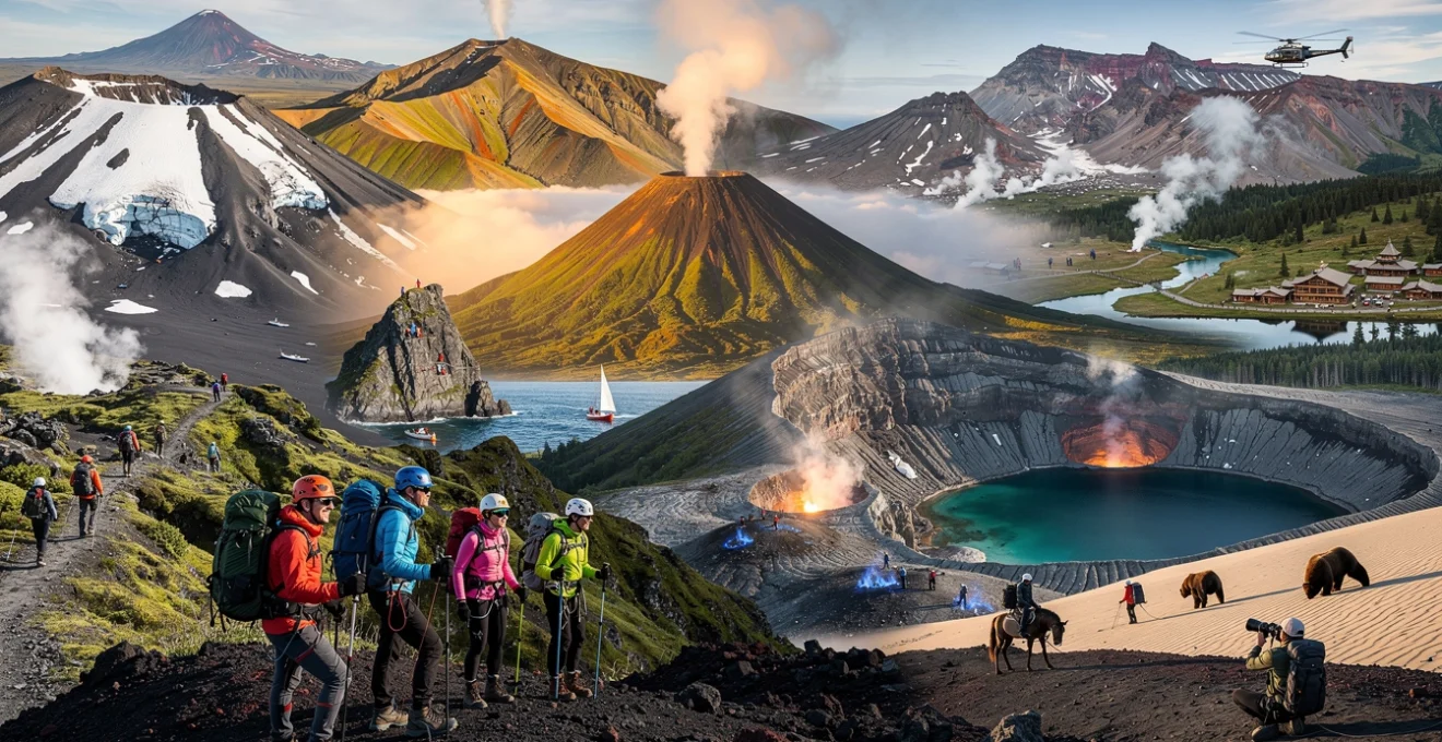
Kamchatka peninsula wilderness: russia’s untouched volcanic frontier
The Kamchatka Peninsula in Russia’s Far East is one of the most remote and least developed volcanic regions accessible to adventure travellers. Containing over 160 volcanoes, 29 of which are active, Kamchatka offers a rare combination of unspoiled wilderness, extensive geothermal activity, and significant wildlife populations. Access is typically via Petropavlovsk-Kamchatsky, from where specialised operators organise helicopter flights, 4×4 expeditions, and multi-day backcountry treks. Because infrastructure is limited and weather patterns are highly unpredictable, Kamchatka expeditions demand a higher level of self-sufficiency and logistical planning than many other volcanic destinations.
For those prepared to commit the time and resources, Kamchatka delivers volcanic landscapes on a continental scale: vast lava plateaux, steaming fumarole fields, glacier-clad summits, and valleys carved by ancient eruptions. Many routes involve river crossings, boggy tundra, and unmarked trails, making navigation skills and physical fitness essential. With brown bears, foxes, and sea eagles commonly encountered, these volcanic adventures also double as wildlife expeditions, requiring strict adherence to safety protocols for human–wildlife interactions. Insurance that covers remote evacuation and technical rescue is strongly recommended for any extended trip into Kamchatka’s volcanic frontier.
Valley of geysers helicopter access: permit requirements and tour operators
The Valley of Geysers, located within the Kronotsky Nature Reserve, is one of the world’s largest geothermal fields and is accessible almost exclusively by helicopter. Due to its protected status and fragile environment, visitor numbers are tightly controlled and require advance permits coordinated through authorised tour operators. Flights typically depart from Petropavlovsk-Kamchatsky, combining aerial views of active volcanoes with guided walks along designated boardwalks that wind between geysers, hot springs, and colourful mineral terraces. Because there are no independent access options, choosing a reputable operator with strong safety records and environmental credentials is essential.
Weather-related cancellations are common, and travellers should build flexibility into their itinerary, as flight windows can be narrow. Once on the ground, strict rules govern movement within the geothermal field to prevent accidents and minimise impact on delicate thermal features. Walking off-trail is prohibited, and guides provide constant oversight to ensure visitors remain within safe zones away from unstable ground and boiling pools. If you are planning to photograph the Valley of Geysers, be prepared for rapidly changing light and steam conditions that can obscure visibility within seconds—much like trying to capture a landscape inside a moving cloud.
Mutnovsky volcano fumarole fields: technical climbing equipment specifications
Mutnovsky Volcano, south of Petropavlovsk-Kamchatsky, is renowned for its extensive fumarole fields, ice caves, and easily observable geothermal activity. Approaches typically involve a combination of off-road vehicle travel and several hours of trekking across snowfields, scree slopes, and glacial meltwater streams. Depending on the season, technical equipment such as crampons, trekking poles, and in some cases a light harness and rope for glacier travel may be required. The fumarole fields themselves present additional hazards, including thin crusts over steam vents and highly acidic runoff that can damage unprotected gear.
For safe navigation in Mutnovsky’s active crater, guides often recommend specific footwear with stiff soles and high ankle support, along with heat-resistant trekking poles that can withstand occasional contact with warm ground. Waterproof gaiters help protect against slush and sulphur-stained snow, while goggles and masks can mitigate irritation from sulphur gases near vents. As with other technical volcano ascents, pack weight must be balanced against safety: carrying too little equipment can compromise security on ice and loose ash, while overpacking may lead to fatigue during the long approach. Working with experienced local outfits ensures that your equipment list is properly calibrated to current conditions.
Kronotsky nature reserve: brown bear encounters and wildlife photography
The Kronotsky Nature Reserve encompasses a mosaic of volcanic landscapes, rivers, and coastal ecosystems that support one of the world’s highest densities of brown bears. For wildlife photographers, this creates unique opportunities to capture bears fishing in salmon-rich rivers with volcanic peaks as a backdrop. Access is tightly regulated, and all visits must be arranged through licensed operators under the supervision of reserve rangers. Group sizes are kept small to minimise disturbance, and guests are typically briefed extensively on behaviour protocols before entering bear habitats.
Safe bear encounters rely on maintaining appropriate distances, avoiding sudden movements, and never carrying food on open display. Telephoto lenses of 300mm or longer are recommended for ethical wildlife photography, allowing you to capture detailed images without approaching animals. Tripods or monopods can help stabilise shots in low light conditions typical of Kamchatka’s variable weather. Because you may spend hours standing in damp tundra or along riverbanks, waterproof boots, layered clothing, and dry bags for camera equipment are essential. In this environment, volcanic adventure and wildlife observation intertwine: you might frame a feeding bear against steaming vents or a distant eruptive plume.
Tolbachik volcanic complex: lava tube exploration and speleological techniques
The Tolbachik volcanic complex gained international attention after its 1975–1976 and 2012–2013 fissure eruptions, which created extensive lava fields and numerous lava tubes. These hollow conduits, formed as the outer surface of a lava flow cooled while molten rock continued to move within, now offer extraordinary opportunities for speleological exploration. Accessing lava tubes safely requires a combination of caving and mountaineering techniques, including controlled descents, three-point contact on jagged basalt surfaces, and constant awareness of loose rock. Because many tubes remain poorly mapped, expeditions typically rely on highly experienced guides and detailed GPS waypoints.
Essential equipment for lava tube exploration includes helmets with dual light sources, gloves resistant to abrasion, and clothing that can withstand contact with sharp, glassy rock fragments. Ropes, harnesses, and anchors may be necessary for vertical sections or unstable entrances, while carbon monoxide detectors are increasingly used to monitor air quality in confined spaces. As with any speleological activity in volcanic terrain, preserving the integrity of fragile formations is a core principle: avoid touching delicate stalactites of sublimated minerals and minimise foot traffic on pristine tube floors. Tolbachik offers an advanced-level adventure best suited to travellers with previous caving or technical trekking experience.
Chilean andes volcanic chain: atacama desert to patagonia
The Chilean Andes stretch over 4,200 kilometres from the hyper-arid Atacama Desert to the glaciated fjords of Patagonia, hosting one of the densest volcanic chains on Earth. More than 90 potentially active volcanoes line this segment of the South American subduction zone, many of them rising in stark contrast to salt flats, high-altitude lagoons, or temperate rainforests. For adventure travellers, Chile offers a rare chance to combine multi-day volcano ascents with desert overland journeys, ski mountaineering, and hot spring soaks in a single country. Well-developed infrastructure in regions like Araucanía and Los Ríos makes accessing volcanic landscapes comparatively straightforward, even for those with limited expedition experience.
Popular volcanic objectives include Villarrica, Llaima, and Osorno, where guided climbs often incorporate glacier travel and controlled ascents to active crater rims. Further north, the Atacama region features high-altitude giants such as Lascar and Ojos del Salado—the latter being the world’s highest active volcano and a coveted objective for experienced mountaineers. In Patagonia, lesser-known volcanoes rise above dense forests and basaltic plateaux, offering quieter routes for those seeking solitude. Throughout Chile, CONAF (the National Forest Corporation) manages park access and may require permits, summit registers, or guide accompaniment depending on current volcanic activity levels and fire risk.
Specialized adventure tourism equipment for volcanic terrain navigation
Volcanic landscapes present a unique combination of hazards—loose ash, razor-sharp lava, corrosive gases, and rapid weather shifts—that standard hiking gear cannot always address. As a result, specialised adventure tourism equipment has become integral to safe navigation in active and dormant volcanic regions. For example, boots with aggressive tread patterns and high ankle support help stabilise movement on scree and ash slopes that behave almost like ball bearings underfoot. Many experienced volcano trekkers also favour boots with heat-resistant soles when travelling across recently cooled lava flows that can still radiate significant warmth.
Respiratory protection is another critical consideration, particularly near fumarole fields, sulphur vents, or ash plumes. Lightweight half-mask respirators with interchangeable filters rated for fine particles and acidic gases provide far better protection than basic dust masks, especially during prolonged exposure. Eye protection with wraparound lenses can shield against both ash and the intense glare of sun reflecting off snow-covered or light-coloured volcanic surfaces. Trekking poles, preferably with tungsten carbide tips, improve balance on unstable terrain and help test the stability of ash or crusted surfaces ahead of each step—much like a blind person’s cane revealing irregularities before they become hazards.
Navigation and communication tools take on heightened importance in volcanic regions where weather can change rapidly and landmarks may be obscured by clouds or steam. GPS devices with preloaded topographic maps, combined with traditional compass and paper map backups, form a redundant system that remains functional even if electronics fail. Satellite messengers and personal locator beacons (PLBs) are increasingly seen as standard equipment for remote volcano treks, allowing travellers to send status updates or emergency signals from areas with no mobile coverage. For multi-day expeditions, lightweight shelters with robust guy-line systems are essential to withstand high winds often funnelled along volcanic ridges and caldera rims.
High-altitude acclimatisation protocols for volcanic peak expeditions
Many of the world’s most iconic volcanoes—such as Cotopaxi, Ojos del Salado, and Mount Etna’s upper slopes—rise to altitudes where reduced oxygen levels can significantly impact performance and safety. Effective acclimatisation protocols are therefore a fundamental part of planning any high-altitude volcanic expedition. A common guideline is to limit sleeping elevation gains to 300–500 metres per day above 2,500 metres and to incorporate regular climb high, sleep low strategies. This might mean ascending to a higher ridge or crater rim during the day before descending to a lower camp for the night, giving your body time to adapt without overloading it.
Hydration and nutrition play crucial roles in the acclimatisation process. High-altitude environments often combine dry air, increased respiration rates, and physical exertion, which can lead to rapid fluid loss even when temperatures feel cool. Drinking small amounts of water frequently, supplementing with electrolytes, and maintaining consistent calorie intake help support physiological adaptation. Monitoring for early symptoms of Acute Mountain Sickness (AMS)—such as headache, nausea, or unusual fatigue—is vital, as these can escalate quickly if ignored. A conservative approach that prioritises descent over summit ambitions when symptoms worsen is the safest strategy, no matter how tempting the volcanic summit may appear.
Pre-acclimatisation strategies, including spending time at moderate altitudes before tackling higher volcanic peaks, can enhance performance and reduce risk. Some travellers use simulated altitude training systems at home, though their effectiveness varies and they should complement rather than replace in-field acclimatisation. Medications such as acetazolamide may be prescribed by travel medicine specialists to support acclimatisation, but they are no substitute for sensible pacing and rest days. Ultimately, treating high-altitude volcano ascents with the same respect as major mountain expeditions—through gradual elevation gain, careful self-monitoring, and readiness to retreat—ensures that your experience of these dramatic volcanic landscapes remains both memorable and safe.