Rural mobility challenges have become increasingly complex as traditional public transport networks face funding cuts and route reductions across the British countryside. The shift from car dependency to sustainable transport alternatives requires careful planning, local knowledge, and access to emerging digital platforms. Modern travellers seeking to explore remote villages, national parks, and rural communities without private vehicles must navigate a patchwork of transport services ranging from established bus networks to innovative demand-responsive systems.
Understanding the diverse transport ecosystem in rural Britain involves recognising both traditional infrastructure and cutting-edge mobility solutions. From heritage railway lines threading through Yorkshire Dales to community transport schemes serving isolated Cornish villages, the landscape of rural connectivity continues to evolve. Digital transformation has revolutionised journey planning, enabling real-time tracking and integrated ticketing across multiple transport modes, while micro-mobility options and car-sharing cooperatives offer flexible alternatives to traditional ownership models.
Public transport networks and timetabling systems in remote british countryside
Rural public transport networks operate on fundamentally different principles compared to urban systems, prioritising connectivity over frequency. The backbone of countryside mobility relies heavily on strategic route planning that connects market towns, railway stations, and key service centres. Timetabling coordination between different operators becomes crucial when passengers need to transfer between bus services or connect with rail networks, particularly in areas where services may operate only once or twice daily.
The challenge of maintaining viable rural transport lies in balancing commercial sustainability with social necessity. Many routes serve essential community functions, connecting residents to healthcare facilities, employment centres, and educational institutions. Government subsidies through the Bus Service Operators Grant and local authority funding help maintain services that would otherwise prove commercially unviable, yet these funding streams face ongoing pressure from budget constraints and changing political priorities.
Arriva bus services and Cross-Country route planning
Arriva’s extensive network across Wales, North West England, and the Midlands demonstrates how major operators adapt their service delivery for rural environments. Their cross-country routes often follow ancient market town patterns, connecting communities that have maintained trading relationships for centuries. Service frequency typically ranges from hourly during peak periods to three or four services per day on more remote routes, with Sunday services significantly reduced or eliminated entirely.
The operator’s approach to rural route planning involves careful consideration of school transport requirements, which often determine morning and afternoon service patterns. Many Arriva routes serve dual purposes, carrying fare-paying passengers alongside students, maximising vehicle utilisation and route viability. Their digital ticketing systems and mobile applications have simplified payment processes, though cash payments remain essential in areas with limited digital connectivity.
National rail enquiries integration with rural branch lines
Railway branch lines represent the arteries of rural public transport, connecting remote communities to the national rail network. The Heart of Wales Line, Cambrian Coast railway, and various preserved heritage railways demonstrate how rail infrastructure continues to serve sparsely populated areas. Integration timing between connecting bus services and rail departures requires precise coordination, as missed connections can result in significant delays given infrequent service patterns.
National Rail Enquiries has enhanced its digital platform to better accommodate rural journey planning, incorporating real-time delay information and alternative route suggestions. The platform now highlights potential connection risks and provides advance warning when tight transfers may prove challenging. This technological advancement proves particularly valuable for visitors unfamiliar with local transport nuances and timing constraints.
Demand responsive transport (DRT) schemes in devon and cornwall
Devon and Cornwall have pioneered innovative demand responsive transport solutions to address the unique challenges of serving scattered rural populations. These schemes operate more like shared taxis than traditional bus services, using advance booking systems to optimise routes based on passenger demand. Booking flexibility allows passengers to specify pickup points near their homes rather than walking to designated bus stops, significantly improving accessibility for elderly or mobility-impaired users.
The success of DRT schemes depends heavily on sophisticated routing algorithms that balance efficiency with service quality. Modern systems can accommodate same-day bookings while maintaining reasonable journey times, though advance booking typically ensures better route optimisation. These services often integrate with conventional bus networks, providing crucial last-mile connectivity to railway stations and market towns where passengers can access wider transport networks.
Community transport associations and Dial-a-Ride services
Community transport associations represent grassroots solutions to rural mobility
Community transport associations represent grassroots solutions to rural mobility challenges, particularly for residents who cannot access mainstream bus or rail services. Typically run as charities or social enterprises, these organisations operate Dial-a-Ride, social car schemes, and community minibuses that prioritise older people, disabled passengers, and those without access to a car. Services are usually membership-based, with a small annual fee and modest journey charges designed to cover fuel and running costs rather than generate profit.
Dial-a-Ride services enable passengers to pre-book door-to-door transport to medical appointments, shopping centres, or social activities, often using accessible vehicles with wheelchair lifts. Many schemes coordinate their timetables around local clinic hours, market days, and community events, effectively acting as a lifeline for people in isolated hamlets. For travellers and new residents, establishing early contact with the nearest community transport association can be as important as finding out the local bus timetable, especially if you expect to be without a vehicle for an extended period.
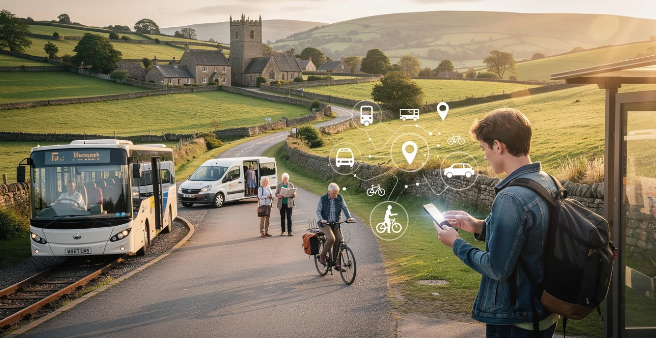
Digital mobility platforms and Real-Time journey planning tools
The rapid growth of digital mobility platforms has transformed how we plan journeys in rural Britain, even where physical infrastructure remains limited. While traditional printed timetables and parish noticeboards still have a role, real-time journey planners allow you to respond quickly to cancellations, delays, or missed connections. Integrated platforms combine data from bus operators, rail companies, and even community transport providers, giving a clearer picture of what is realistically possible without your own vehicle.
However, digital tools are only as useful as the information they contain. In some remote areas, patchy mobile coverage and incomplete data feeds can make live tracking unreliable or delayed. For that reason, the most effective rural travel strategy blends technology with local knowledge: using journey planning apps alongside advice from tourist information centres, accommodation hosts, and local residents who understand which services actually run on the ground.
Traveline SW and Multi-Modal trip planning applications
Traveline South West (often branded as Traveline SW) is a key resource for planning journeys across Devon, Cornwall, Somerset, and neighbouring counties. Unlike commercial apps that focus on large cities, Traveline collates information from dozens of smaller bus operators, ferry services, and some community routes, providing a more complete overview of rural public transport. You can enter a postcode, village name, or landmark and receive step-by-step options that may combine local buses, mainline trains, and occasional coach links.
Because Traveline SW is designed specifically with complex, cross-operator journeys in mind, it excels at stitching together connections that would be hard to discover manually. For example, you might see that an early morning village bus aligns with a market town departure, which in turn meets a regional train at an interchange node. Used carefully, this type of multi-modal planner can help you build car-free itineraries that balance travel time with realistic connection margins, reducing the risk of being stranded.
Citymapper rural coverage and google maps public transport integration
Citymapper is best known for its slick interface in major cities, but its usefulness drops sharply in sparse rural areas where data coverage is limited. In many parts of the British countryside, Citymapper will show only rail services or none at all, making it a complementary tool rather than a primary planner. If you are staying on the outskirts of a larger town or in a national park near a busy commuter corridor, it may still be valuable for the urban legs of your journey.
Google Maps offers broader public transport coverage across the UK, including numerous rural bus routes and some demand-responsive services. Its strength lies in familiarity and ease of use: you can quickly check when the next bus leaves a small village stop or verify walking times between stations and stops. However, like a rough sketch rather than a detailed ordnance survey, Google’s data can miss infrequent services or seasonal changes. For critical journeys—such as the last bus of the day back to your accommodation—it is wise to cross-check Google’s suggestions against operator websites or regional planners like Traveline.
First bus mobile app and live tracking functionality
Where First Bus operates rural or semi-rural routes, its dedicated mobile app can provide a level of precision that generalist platforms cannot match. Live tracking functionality shows bus locations in real time, allowing you to see whether a vehicle is running late, has already passed your stop, or is stuck in traffic approaching a bottleneck. For passengers waiting on a windy moorland roadside or in a remote village lay-by, knowing that the bus is five minutes away rather than twenty can make a huge difference in comfort and confidence.
The app also supports mobile ticketing, which can reduce the need to carry exact change or handle paper tickets on multi-leg journeys. Yet it is important to remember that not all rural passengers have smartphones, and some areas experience weak or intermittent data signals. Sensible travellers download tickets and key timetables in advance over Wi‑Fi, and keep a backup plan—such as printed screenshots or written times—in case connectivity fails at the worst possible moment.
Moovit Crowd-Sourced data for village bus stops
Moovit takes a hybrid approach by combining official timetable feeds with crowd-sourced reports from users on the ground. In theory, this makes it particularly valuable in villages where minor timetable changes or temporary diversions are slow to reach central databases. A driver who consistently arrives early or late, or a route affected by roadworks, may be flagged more quickly by regular passengers than by formal channels. Over time, this collective intelligence can paint a more realistic picture of how rural services actually run.
Of course, crowd-sourced information is more like a conversation in the village pub than a legal contract: helpful, but not infallible. For that reason, Moovit works best as a supplementary tool to verify your expectations rather than the sole source of truth. If several recent users report that a particular afternoon bus has been cancelled all week, you might reasonably plan for an alternative, whether that means catching an earlier service, arranging a taxi share, or rescheduling your appointment.
Alternative transportation methods and Micro-Mobility solutions
Even with well-planned public transport, there will be gaps in rural networks where buses simply do not go, or run only once a week. This is where alternative transport methods and micro-mobility solutions come into their own, filling the “last mile” between village bus stops and dispersed homes or trailheads. From electric bikes to community car-sharing clubs, these tools allow you to live or travel without owning a car while still accessing nature, employment, and essential services.
Think of these options as a toolkit rather than a single solution. On one day, you might hop on an e‑bike to reach a national park visitor centre from the nearest station; on another, you might book a liftshare to a farmers’ market or use a pre-booked taxi to connect with an evening train. The more flexible your mindset, the easier it becomes to stitch together reliable journeys without your own vehicle.
Electric bicycle rental networks in peak district national park
The Peak District National Park has become a testbed for electric bicycle rentals and cycling hubs designed to encourage low-carbon, car-free access. E‑bike hire centres near railheads such as Sheffield, Buxton, and Matlock enable visitors to step off a train and onto a bike, bypassing the need for mountain roads and crowded car parks. Assisted pedalling flattens steep climbs and makes longer distances feasible, especially for travellers who might not otherwise attempt hilly terrain.
Using an e‑bike in the countryside is often likened to having a gentle tailwind wherever you go: you still need to pedal, but the effort feels more like a brisk walk than a strenuous workout. For residents, membership schemes and multi-day hire can make regular use cost-effective, particularly when compared to the expense of owning and maintaining a car. Planning routes in advance using national cycle network maps and checking battery range against anticipated hills helps ensure you do not run out of power halfway across an exposed moor.
Car sharing cooperatives and liftshare platforms
Car sharing cooperatives and online liftshare platforms offer a middle ground between complete car ownership and total reliance on public transport. In many rural communities, neighbours already give each other informal lifts to the supermarket, hospital, or school; digital platforms formalise this arrangement by matching drivers with spare seats to passengers heading in the same direction. By sharing fuel and parking costs, both parties benefit financially, while the number of vehicles on the road is reduced.
Formal car clubs operate on a similar principle but provide access to shared vehicles that can be booked by the hour or day, typically stored in village centres or small towns. For someone living rurally without a car, occasional use of a cooperative vehicle can make larger shopping trips, DIY store runs, or family visits possible without the full-time costs of insurance and tax. The key is to book early for peak times and to be realistic about your flexibility—if you must be somewhere at a fixed time, you may want a backup option in case no suitable liftshare emerges.
Walking route navigation using ordnance survey maps
In rural Britain, walking is not just a leisure activity; it is often a practical transport mode, especially for the last mile from bus stops to homes, campsites, or workplaces. Ordnance Survey (OS) maps remain the gold standard for navigating footpaths, bridleways, and permissive tracks that do not appear on standard road maps. Whether in paper form or via digital apps, OS mapping allows you to plot safe, legal routes across farmland and open access land, avoiding busy A‑roads with no pavements.
Using OS maps can feel at first like learning a new language, with contour lines, rights-of-way symbols, and field boundaries forming a complex code. Yet once you have decoded it, the countryside opens up like a hidden subway network beneath a city, revealing direct routes that drivers cannot use. Combining OS mapping with GPS on a smartphone—or a basic compass as backup—helps prevent you from straying off rights of way, and is especially useful in poor visibility or fading light when landmarks become harder to identify.
Taxi and private hire vehicle booking systems
Taxi and private hire services play a crucial role in rural areas, particularly when public transport does not operate at the times you need. Unlike in cities where you might hail a cab on the street, rural taxis almost always require pre-booking by phone or via simple online forms. Many operators cover wide geographic areas, so you can arrange transfers between remote campsites, small villages, and larger transport hubs like railway stations or coach stops.
Because distances can be long and meter rates high, using taxis strategically is key to keeping costs manageable. One common tactic is to use a taxi only for the most difficult stretch of a journey—perhaps a seven-mile leg along an unlit road—while relying on buses or trains for the remainder. Some villages maintain informal taxi-sharing noticeboards in shops or community centres, allowing locals and visitors to coordinate rides and split fares where possible.
Regional case studies and accessibility assessment
Understanding how all these elements work in practice is easier when we look at specific regions. Take the Yorkshire Dales, for example: a patchwork of small villages, scattered farms, and market towns served by a mix of scheduled buses, school-day services, and seasonal tourist routes. Travellers without cars often base themselves in hubs such as Skipton or Settle, where mainline rail meets local bus networks, and then use walking routes and occasional taxis to explore surrounding valleys.
In contrast, Cornwall presents longer distances and more dispersed settlements, but benefits from integrated bus and train timetables along the main coastal corridors. Here, demand responsive transport plugs gaps inland, while community transport organisations coordinate regular trips to Truro or Penzance for shopping and medical appointments. Accessibility assessments conducted by local authorities increasingly incorporate digital tools, analysing which communities lack reasonable access to essential services within a set travel time by public or shared transport.
These case studies highlight a vital point: rural mobility is highly localised. What works well in the Peak District—where e‑bike hire and rail access are strong—may be less effective in the Scottish Highlands, where long, single-track roads and sparse population make taxis and community minibuses more prominent. Before committing to living or travelling car-free in a particular area, it is sensible to map your regular destinations (shops, GP surgeries, social spaces) against available services. In doing so, you effectively create your own “accessibility profile” and can identify any serious gaps before they become day-to-day frustrations.
Cost-effective travel strategies and concessionary fare schemes
Living or travelling without a vehicle in rural Britain can be economically attractive, but only if you plan your spending carefully. Individual bus and rail tickets bought on the day quickly add up, especially where services are run by multiple operators without integrated fares. A more strategic approach involves identifying the tickets, passes, and concession schemes that match your typical travel patterns, then building your journeys around them as much as possible.
In England, older and disabled residents may be eligible for concessionary bus passes that provide free off-peak travel on local services, dramatically reducing the cost of regular trips to market towns or medical appointments. Some county councils supplement national schemes with local deals, such as evening or weekend discounts, to encourage bus use. For rail travel, advance tickets and regional rover passes offer good value when booked early, but require you to commit to specific trains or travel windows—something to consider if you are depending on connecting buses that might be delayed.
For those without access to concessions, simple budgeting techniques still help keep rural travel costs under control. Grouping errands into one market-day trip rather than several separate journeys can halve weekly expenditure, while travelling slightly earlier or later in the day may unlock off-peak rail fares. Many bus operators also offer multi-journey tickets or capping systems, where after a certain spend in a day or week additional rides are free; understanding these structures allows you to make the most of a limited budget without sacrificing essential mobility.
Emergency transport protocols and contingency planning for isolated communities
No matter how well you plan, rural life without a private vehicle will occasionally throw up emergencies: a sudden illness at night, an unexpected cancellation of the only bus home, or extreme weather cutting off roads. Preparing for these scenarios in advance is as important as learning the regular timetable. In many areas, local resilience groups, parish councils, and community transport associations have informal protocols to help ensure vulnerable residents are not left stranded.
At a personal level, building your own contingency plan can be as simple as keeping a list of taxi numbers, nearby neighbours with cars, and community volunteers who have offered help in an emergency. If you have ongoing medical needs, discussing transport arrangements with your GP practice or local health authority can reveal patient transport services that do not appear in standard journey planners. For visitors, informing your accommodation host of your intended routes and expected return times offers a basic safety net if you are delayed or forced to alter your plans.
On a wider scale, extreme weather events—such as heavy snow, flooding, or storms—often lead councils to publish updated information on road closures and disrupted services via social media and local radio. Having a battery-powered radio, offline maps, and some flexibility in your schedule can prevent a temporary disruption from becoming a crisis. Ultimately, navigating rural areas without your own vehicle is a balance between independence and interdependence: you rely more on shared systems and community networks, but in return you gain a deeper connection to the places and people that sustain life in the countryside.