Our planet harbours geological masterpieces that defy imagination, from volcanic archipelagos sculpted by millennia of eruptions to arctic formations shaped by glacial forces beyond human timescales. These landscapes represent Earth’s most dramatic expressions of natural artistry, where geological processes have created scenery so spectacular that they challenge our understanding of what’s possible in the natural world. Each formation tells a story of immense forces at work—volcanic activity, glacial movement, wind erosion, and tectonic shifts—creating destinations that inspire awe in even the most seasoned travellers. The diversity of these landscapes spans every climate zone and geological setting, offering experiences that range from the ethereal beauty of ice-carved fjords to the surreal majesty of desert slot canyons.
Arctic and Sub-Arctic terrestrial formations
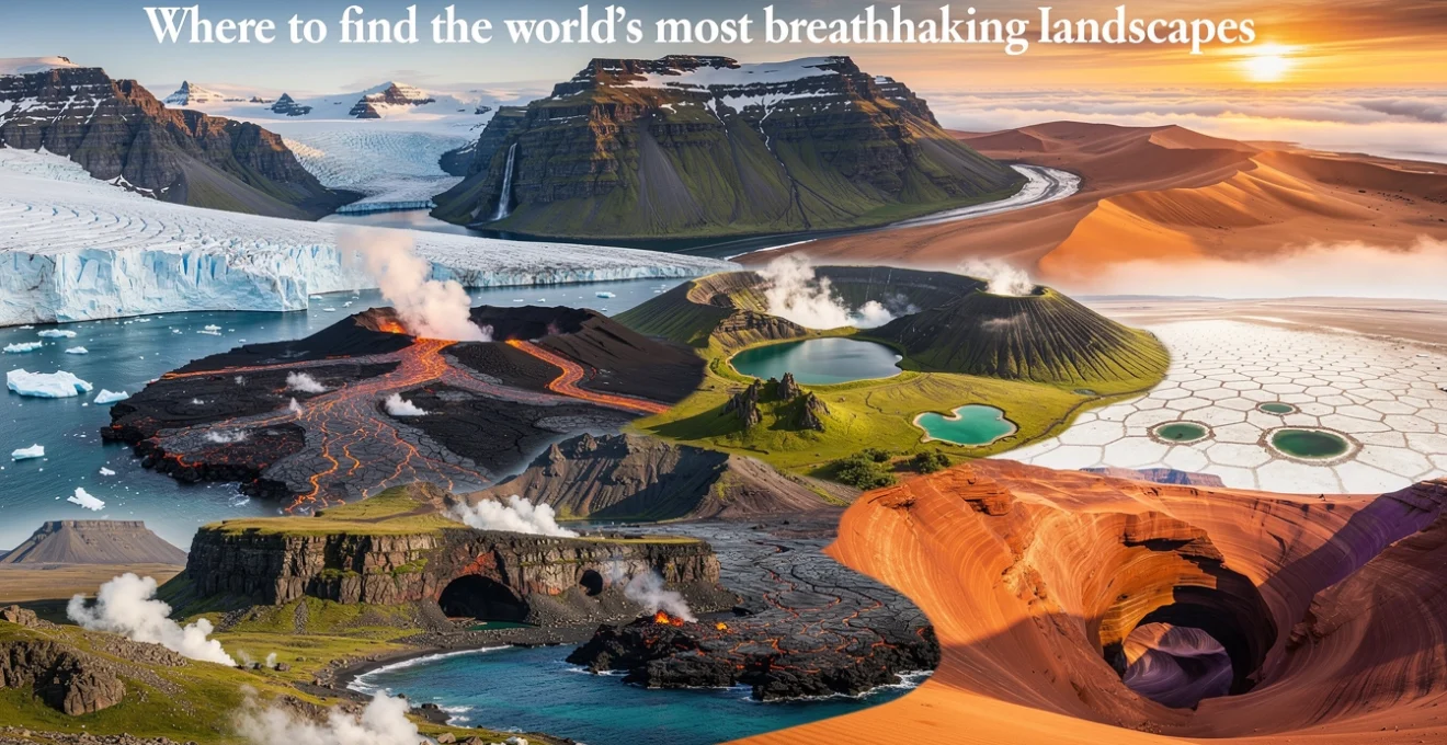
The Arctic regions showcase some of Earth’s most pristine and dramatically sculpted landscapes, where ice has served as the primary architect for thousands of years. These formations represent the planet’s most extreme environments, where geological processes operate under conditions that create unique and spectacular terrain features.
Svalbard’s glacial moraines and permafrost polygons
Svalbard’s landscape bears the unmistakable signature of glacial activity, with moraines creating dramatic ridges across the archipelago’s valleys. These glacial deposits form intricate patterns that tell the story of ice sheet advances and retreats over millennia. The permafrost polygons create geometric patterns across the tundra, forming natural tessellations that can span hundreds of metres. During the brief Arctic summer, these formations become particularly visible as the active layer thaws, revealing the complex structure of permanently frozen ground beneath.
The archipelago’s terrain showcases lateral and terminal moraines that create natural barriers between valleys, while the permafrost polygons demonstrate the powerful effects of freeze-thaw cycles. These formations are most accessible during the midnight sun period from April to August, when temperatures occasionally rise above freezing and allow for detailed observation of these remarkable geological features.
Iceland’s volcanic fissure systems and geothermal fields
Iceland sits astride the Mid-Atlantic Ridge, creating a landscape where volcanic fissure systems stretch across the island like geological wounds that periodically burst into fiery activity. The Reykjanes Peninsula and the Northern Volcanic Zone showcase these fissure systems most dramatically, with parallel ridges and valleys carved by repeated volcanic eruptions. Geothermal fields dot the landscape, creating otherworldly scenes of steaming vents, coloured mineral deposits, and bubbling mud pools.
The interplay between volcanic activity and glacial ice creates unique formations found nowhere else on Earth. Areas like Landmannalaugar demonstrate this combination perfectly, where rhyolite mountains display rainbow colours from mineral deposits, while nearby glacial rivers carve through recent lava flows. The geothermal activity continues to reshape the landscape daily, making Iceland a living laboratory of geological processes.
Greenland’s nunataks and ice sheet calving fronts
Greenland’s massive ice sheet, covering 80% of the island, creates some of the most dramatic landscape contrasts imaginable. Nunataks—rocky peaks that pierce through the ice sheet—create isolated mountain islands in an ocean of white, offering spectacular viewpoints over the seemingly endless glacial expanse. These formations provide crucial insights into the underlying geology of Greenland, which remains largely hidden beneath kilometres of ice.
The calving fronts along Greenland’s coast present dynamic landscapes where glaciers meet the sea in spectacular fashion. Ice cliffs can tower 100 metres above sea level, with even more ice hidden beneath the water’s surface. The Ilulissat Icefjord, a UNESCO World Heritage site, exemplifies these formations, where the Jakobshavn Glacier produces icebergs at a rate that makes it one of the most active glacial fronts in the Northern Hemisphere.
Norwegian fjord cirques and hanging valley formations
Norway’s fjordlands represent the pinnacle of glacial landscape architecture, where massive ice sheets carved deep valleys that now host some of the world’s most spectacular waterscapes. Glacial cirques—amphith
cirical basins carved high on the mountain flanks—form the birthplaces of many fjords, while hanging valleys join the main fjord walls in dramatic waterfalls that can plunge hundreds of metres to the sea below.
Iconic fjord systems such as Geirangerfjord and Nærøyfjord illustrate these glacial cirques and hanging valley formations with exceptional clarity. From above, you can trace the classic U-shaped valleys left behind by retreating glaciers; from the water, sheer rock walls rise almost vertically, punctuated by narrow inlets where tributary glaciers once flowed. Visiting in late spring or early autumn offers the best combination of manageable weather, fewer crowds, and snow still capping the higher cirques, emphasising the vertical relief of this breathtaking landscape.
Tropical and subtropical volcanic archipelagos
Across the tropics and subtropics, volcanic island chains showcase how fire and water collaborate to create some of the world’s most breathtaking landscapes. These archipelagos sit atop tectonic hotspots or along mid-ocean ridges, where repeated eruptions have built entire islands from the seafloor up. Over time, erosion, coral growth, and vegetation transform bare lava into complex ecosystems, layering lush forests and rich marine life over stark volcanic foundations.
For travellers, these volcanic archipelagos offer a rare chance to see active geology in real time. You can walk across fresh lava fields that are younger than you are, descend into ancient lava tubes, or soak in geothermal pools heated by magma chambers deep below. Many of these islands also protect endemic species found nowhere else, turning each visit into a combination of geological field trip and biodiversity expedition.
Galápagos volcanic shield formations and lava tube networks
The Galápagos Islands are textbook examples of volcanic shield formations—broad, gently sloping volcanoes built from successive basaltic lava flows. Unlike the steep stratovolcanoes seen in many continental regions, these shield volcanoes spread outward like inverted shallow bowls, creating smooth profiles that extend far beneath the sea surface. On islands such as Isabela and Fernandina, you can still see active vents, collapsed craters, and fresh lava fields that record eruptions from the last few decades.
Beneath the surface, extensive lava tube networks snake through the bedrock, formed when the outer skin of a lava flow cooled and hardened while molten lava continued to move inside. When the flow eventually drained, it left behind hollow tunnels that can stretch for kilometres. Walking through these lava tubes—some large enough to drive a car through—feels like entering the planet’s circulatory system, where you can read past eruptions in the layers of rock around you. Guided visits focus on both safety and conservation, as these fragile formations can be easily damaged by careless traffic.
Hawaiian pyroclastic cones and basaltic flow fields
Hawai‘i’s landscapes are dominated by vast basaltic flow fields and smaller pyroclastic cones that dot the larger volcano flanks. The basaltic flows, often only a few metres thick, spread in overlapping sheets that resemble frozen waves, preserving textures from ropey pāhoehoe to jagged ‘a‘ā. On the Island of Hawai‘i, fields from recent eruptions in the 20th and 21st centuries allow you to see how vegetation slowly reclaims bare rock, with hardy pioneer plants establishing the first footholds in nutrient-poor lava.
Pyroclastic cones—steep-sided hills built from volcanic cinders, ash, and bombs—add dramatic silhouettes to this basaltic backdrop. Icons like Sunset Crater near Mauna Kea or smaller cinder cones along the flanks of Mauna Loa demonstrate how explosive episodes punctuate otherwise fluid basaltic volcanism. Visitor centres and national parks provide detailed interpretation of these features, and well-marked trails let you explore flow fronts, skylights into lava tubes, and high cinder rims where you can look directly into dormant craters.
Azores crater lakes and fumarole thermal springs
Set in the mid-Atlantic, the Azores archipelago showcases a different phase in volcanic island evolution, where large calderas have partially filled with water to form crater lakes. On São Miguel, Sete Cidades and Lagoa do Fogo are classic examples: steep caldera walls ring deep blue-green waters, creating amphitheatres of forest, pasture, and cloud. These crater lakes are more than scenic—they record climatic and volcanic events in their sediments, making them natural archives for scientists studying past eruptions and environmental change.
Active fumarole fields and thermal springs reveal that the volcanic systems beneath the Azores are still very much alive. In places like Furnas, steam vents, boiling mud pools, and mineral-rich springs break through the surface, releasing volcanic gases and heat. Locals have long used these geothermal resources for cooking and bathing, and today you can sample traditional dishes slow-cooked in the hot ground or relax in iron-rich thermal pools. As with all geothermal sites, staying on marked paths and respecting safety barriers is essential, as thin crusts can conceal scalding water just below the surface.
Canary islands caldera complexes and parasitic cone clusters
The Canary Islands offer an intricate mosaic of caldera complexes and parasitic cone clusters that reveal multiple cycles of volcanic construction and collapse. Massive calderas such as La Caldera de Taburiente on La Palma or Teide’s Las Cañadas on Tenerife mark the sites of ancient, catastrophic eruptions and subsequent erosion. Today, these depressions host pine forests, cloud-fed ravines, and observatories that take advantage of the clear Atlantic skies—reminders that even violent geological histories can give way to tranquil modern landscapes.
Radiating from the main volcanic edifices, parasitic cones—also known as satellite cones—dot the flanks like beads on a string. These smaller vents, aligned along fissures, record more recent eruptive episodes, including the 2021 Cumbre Vieja eruption on La Palma. Hiking routes across the islands allow you to traverse sequences of cones and flows that read like a timeline of volcanic activity. Because many of these surfaces are still geologically young and sparsely vegetated, erosion patterns, ash layers, and bomb craters remain clearly visible, offering a vivid outdoor classroom on volcanic processes.
Desert sand formations and arid geological structures
Desert regions condense the action of wind, temperature extremes, and sporadic water flows into landscapes that appear simple from afar but reveal intricate details up close. From towering dunes along coastal deserts to narrow slot canyons carved by flash floods, arid environments showcase some of the world’s most striking geological sculptures. Here, erosion acts like a patient sculptor, working grain by grain over millions of years.
For travellers seeking the world’s most breathtaking landscapes, deserts offer both grand vistas and intimate textures. You might stand on a dune crest watching fog roll in from a cold ocean, then a day later find yourself in a sandstone corridor where sunlight filters in as a glowing ribbon. Because conditions can be harsh—extreme heat by day, sudden cold at night, and limited water—planning and respect for the environment are critical for safe and responsible exploration.
Namibian coastal fog desert dune systems
The Namib Desert along Namibia’s Atlantic coast is one of the oldest deserts on Earth, and its dune systems are among the most photogenic landscapes anywhere. Here, some dunes exceed 300 metres in height, rising like molten waves frozen in place. What makes this desert exceptional is its relationship with the cold Benguela Current offshore, which generates dense coastal fog that drifts inland and condenses on dune surfaces, providing vital moisture in an otherwise hyper-arid environment.
This fog-driven ecosystem supports specialized plants and animals that have evolved to capture water directly from the air—an adaptation that fascinates biologists and travellers alike. Iconic areas like Sossusvlei and Deadvlei illustrate how shifting dunes can isolate former riverbeds, leaving behind white clay pans dotted with long-dead camelthorn trees that now stand as dark silhouettes against burnt-orange sand. Visiting at sunrise or sunset maximises both comfort and photography potential, as low-angle light emphasises dune ridges and casts long, dramatic shadows.
Atacama salt flat evaporite deposits and thermal springs
Chile’s Atacama Desert is often described as the driest non-polar desert in the world, and its salt flats and evaporite deposits create landscapes that feel almost extraterrestrial. The Salar de Atacama and smaller salars nearby consist of thick crusts of halite, gypsum, and other minerals left behind as ancient lakes evaporated under intense sun and minimal rainfall. From above, these salt flats resemble cracked porcelain; up close, you can see polygonal patterns where the crust has buckled and fractured.
Thermal springs and geyser fields, such as El Tatio at over 4,000 metres elevation, add another dimension to this arid environment. Here, superheated water rises along fault lines to erupt in boiling pools and geysers, especially vivid in the cold dawn air when steam plumes are most visible. Because of the extreme altitude and dryness, acclimatisation and hydration are crucial for visitors. In return for your preparation, you’ll be rewarded with one of the planet’s clearest night skies, where stargazing over salt flats and steaming vents completes the sense of standing on another world.
Antelope canyon slot formation erosional patterns
Antelope Canyon in northern Arizona is a classic example of a slot canyon carved into Navajo Sandstone by repeated flash floods. Over thousands of years, rapidly moving water loaded with sand and gravel has etched narrow corridors with smooth, flowing walls that twist and curve like liquid stone. The result is a labyrinth of passageways sometimes no wider than a person’s shoulders, where light filters down from above in shafts that turn the rock various shades of orange, red, and violet.
The erosional patterns inside Antelope Canyon and similar formations are a study in how water exploits small weaknesses in rock. Subtle variations in grain size, cementation, and joint orientation create ledges, alcoves, and fluted surfaces that catch both light and the photographer’s eye. Because flash floods remain an active hazard, guided tours are mandatory, and weather monitoring is taken seriously. Standing in these sculpted corridors, you gain a visceral appreciation of how even rare, short-lived storms can shape some of the world’s most breathtaking landscapes.
Monument valley sandstone mesa and butte formations
Straddling the Arizona–Utah border, Monument Valley’s sandstone mesas and buttes rise abruptly from a high desert plain, forming one of the most recognisable landscapes on Earth. These isolated rock towers are remnants of a once-continuous plateau, stripped back by millions of years of wind and water erosion. Mesas—broad-topped with steep sides—represent an early stage in this erosional sequence, while the narrower buttes and slender spires mark later stages as protective caprock and weaker underlying layers are progressively worn away.
The valley’s rich red hues come from iron oxide in the sandstone, which glows warmly at sunrise and sunset. Travellers driving or joining guided tours through Navajo Tribal Park can see how subtle changes in viewpoint dramatically alter the apparent alignment of mesas and buttes, like pieces on a giant stone chessboard. Cultural interpretation by Navajo guides adds depth, linking geological formations with stories and traditions that have shaped local identity for generations.
Mountainous alpine and subalpine ecosystems
High mountain regions combine imposing geology with finely tuned ecosystems that cling to narrow bands of suitable climate. From jagged alpine ridges to gentler subalpine meadows, elevation controls everything: temperature, precipitation, vegetation, and even the thickness of the soil itself. Crossing a vertical kilometre in these environments can feel like travelling from one biome to another, compressing hundreds of kilometres of horizontal distance into a single steep slope.
What makes alpine and subalpine landscapes some of the world’s most breathtaking is the contrast between their apparent harshness and the delicacy of the life they support. Glaciers, cirques, arêtes, and tarn lakes tell the story of past ice ages, while cushion plants, hardy conifers, and migratory animals demonstrate modern adaptation to extreme conditions. As climate change accelerates, these high-altitude ecosystems are also among the most vulnerable, making responsible visitation more important than ever.
Classic alpine scenery is found in ranges such as the European Alps, North America’s Rockies and Sierra Nevada, the South Island of New Zealand, and the Himalaya. Here, you can trace former glacial pathways by following chains of moraines and overdeepenings that now hold brilliant blue lakes. Subalpine zones just below the treeline often host some of the most accessible and rewarding trails, with flower-filled meadows, larch or spruce forests, and broad views of snow-covered peaks rising above.
For hikers and photographers, timing a visit is crucial. Late spring and early summer often bring wildflower displays to subalpine meadows, while late summer and early autumn offer clearer skies and more stable weather for high passes and ridge walks. Because weather can change rapidly—even in peak season—proper gear, navigation tools, and awareness of altitude effects are essential. Treating mountains with the same respect you would give an ocean or a desert helps ensure both your safety and the long-term health of these fragile environments.
Coastal marine terraces and limestone karst topography
Along some shorelines and in certain tropical interiors, the interaction of tectonics, sea-level change, and chemical weathering has created landscapes that seem almost architectural in their precision. Marine terraces step down toward the sea like giant staircases, each level marking a former shoreline uplifted by tectonic forces. Inland, limestone karst regions transform relatively uniform rock layers into towers, sinkholes, caves, and underground rivers through the slow but relentless action of slightly acidic water.
These coastal and karst environments are among the most informative natural records of Earth’s past climates and sea levels. Marine terraces, for instance, allow geologists to reconstruct uplift rates and ocean conditions over hundreds of thousands of years. Karst systems, with their stalactite-lined caves and subterranean streams, act like three-dimensional maps of groundwater movement, revealing how water shapes rock from the inside out. For travellers, they offer everything from panoramic coastal drives to cave dives and multi-day trekking routes through labyrinthine limestone.
Famous examples of marine terraces include the uplifted coasts of New Zealand’s South Island, California’s Big Sur, and parts of Japan and the Mediterranean, where wave-cut platforms have been stranded high above current sea level. Standing on one of these flat benches, you’re effectively walking along an ancient beach now occupied by scrub, forest, or farmland. The regular spacing of terraces can feel almost artificial, like giant steps built for a vanished ocean, yet each one reflects a specific combination of tectonic uplift and sea-level standstill in Earth’s dynamic history.
Karst topography is perhaps best known from regions such as China’s Guilin and Yangshuo, Vietnam’s Ha Long Bay and Ninh Binh, and the tower karst of Thailand and the Philippines. Here, limestone has been dissolved into steep pinnacles, cones, and cliffs, often rising directly from rice paddies or emerald seas. Caves and sinkholes—known as dolines—dot the landscape, many of them harbouring unique ecosystems adapted to low light and stable temperatures. Exploring these areas requires a balance of curiosity and caution: while guided cave tours and marked trails offer safe access, venturing off-route can endanger both you and fragile cave formations that have taken tens of thousands of years to grow.
Whether you’re tracing terraces along a rugged coastline or paddling between karst towers on a still morning, these landscapes remind us that even seemingly solid rock is part of a long, ongoing conversation between Earth’s surface and its deeper processes. By travelling thoughtfully—staying on established paths, supporting local conservation efforts, and learning about the forces that created what you see—you become part of that story too, helping to ensure that the world’s most breathtaking landscapes remain intact for future explorers.