The Mediterranean Sea cradles some of the world’s most coveted destinations, yet beyond the crowded promenades of Barcelona and the Instagram queues of Santorini lie pockets of pristine coastline and ancient settlements that remain largely untouched by mass tourism. These hidden enclaves offer travellers the opportunity to experience authentic Mediterranean culture, where traditional fishing boats still outnumber luxury yachts and local shepherds’ paths wind through landscapes unchanged for centuries.
From remote Greek islands where archaeological treasures emerge from crystal-clear waters to Croatian islets accessible only by private boat, these destinations represent the Mediterranean as it existed before tourism transformed entire coastlines. The challenge lies not in finding these places—they exist in abundance—but in reaching them before word spreads and development inevitably follows.
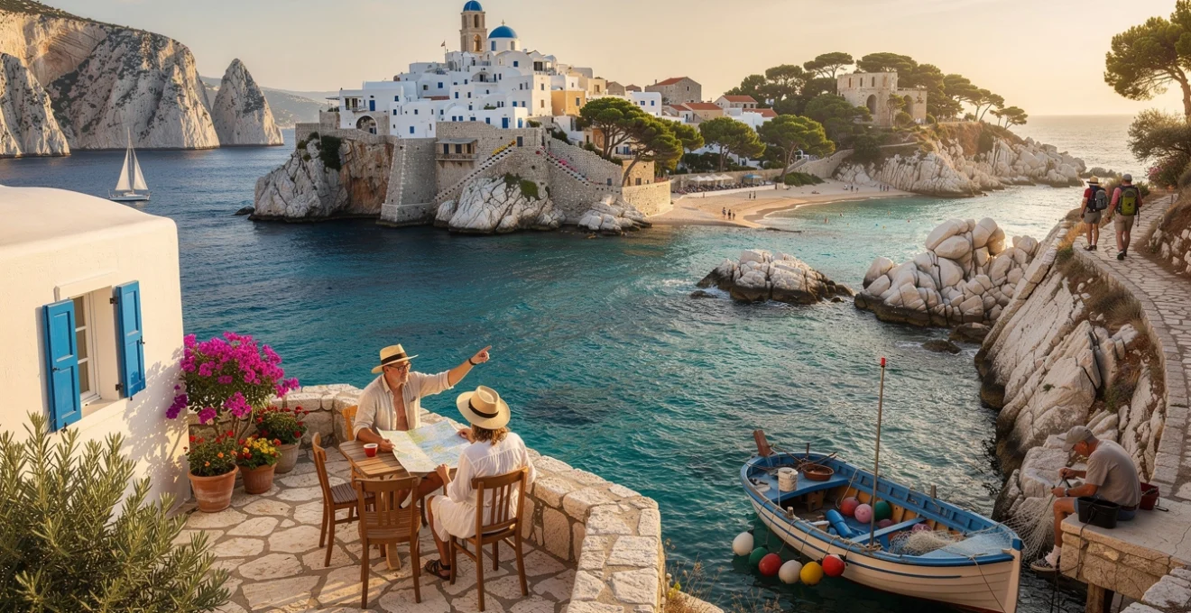
Remote aegean archipelagos beyond santorini and mykonos
The Cycladic islands stretch across the Aegean Sea like scattered pearls, yet most visitors venture no further than the famous duo of Santorini and Mykonos. Beyond these tourism magnets lie dozens of islands where traditional Greek life continues largely undisturbed, offering profound cultural immersion and natural beauty without the crushing crowds.
Antikythera island: archaeological significance and pristine marine ecosystems
Positioned strategically between Crete and the Peloponnese, Antikythera houses fewer than 50 permanent residents yet holds extraordinary archaeological significance. The island’s waters yielded the famous Antikythera mechanism, an ancient Greek analog computer that revolutionised understanding of classical civilisation’s technological capabilities. Today, ongoing excavations continue to reveal bronze statues and marble sculptures from Roman-era shipwrecks.
The island’s isolation has created a marine sanctuary where Posidonia oceanica seagrass meadows flourish undisturbed, supporting populations of Mediterranean monk seals and nesting sites for loggerhead sea turtles. Visitors typically arrive via the weekly ferry from Cythera or private boat, finding accommodation in traditional stone houses that local families have converted into simple guesthouses.
Folegandros cliffside villages and traditional cycladic architecture
Folegandros rises dramatically from the Aegean, its clifftop Chora village perched 200 metres above sea level on volcanic rock formations. The settlement’s narrow marble-paved streets wind between pristine examples of Cycladic architecture, where cubic white houses cascade down terraced hillsides without a single modern intrusion disrupting the traditional aesthetic.
Local families maintain ancient agricultural practices on terraced fields carved into steep hillsides, cultivating indigenous grape varieties and producing small quantities of distinctive wine characterised by mineral-rich volcanic soil. The island’s three sandy beaches—Katergo, Livadaki, and Angali—remain accessible only by footpath or boat, ensuring their preservation from large-scale development.
Amorgos eastern coastline: monastery of panagia hozoviotissa access routes
The Byzantine Monastery of Panagia Hozoviotissa clings impossibly to Amorgos’s eastern cliff face, its white façade embedded directly into vertical rock 300 metres above the Aegean. Built in 1017 AD, the monastery houses miraculous icons and ancient manuscripts while serving as the endpoint for dramatic hiking trails that traverse the island’s spine through aromatic herb-covered hillsides.
Traditional paths connect remote settlements like Tholaria and Langada, where elderly residents maintain stone houses and cultivate ancient olive groves using methods unchanged since medieval times. The eastern coastline features secluded coves accessible only by scrambling down rocky paths, where crystal-clear waters reveal underwater caves and pristine marine ecosystems protected by the area’s remoteness.
Sikinos volcanic terroir and ancient episkopi ruins
Sikinos supports barely 300 residents across an island landscape shaped by volcanic activity that created unique terroir for indigenous wine production. Local vintners cultivate rare Aidani and Fokiano grape varieties on terraced vineyards that follow ancient field boundaries marked by dry-stone walls
that have survived both erosion and modern construction. Above these vineyards sits Episkopi, a Roman-era mausoleum later converted into a Byzantine church, where ongoing conservation work has revealed ancient inscriptions and sculptural fragments. Walking the stone-paved path to Episkopi at dusk, with only cicadas and the distant sound of goat bells for company, you understand how completely Sikinos has resisted the pressures of mass tourism. Simple family-run rooms in Chora and a single bus line serve the island, so visitors need to plan around sparse timetables and embrace slow travel as part of the experience.
Undiscovered croatian coastal enclaves and dalmatian islets
Croatia’s Adriatic coastline is no longer a secret, yet much of the attention concentrates on Dubrovnik, Split and Hvar. Step just beyond the main ferry routes and you find islands where pine forests still outnumber beach bars and stone villages feel lived-in rather than staged. These lesser-known Croatian enclaves offer the same translucent waters and Venetian architecture, but with space to breathe and the time to build genuine connections with local communities.
Vis island military heritage sites and blue cave geological formations
For most of the 20th century, Vis was a closed Yugoslav military base, off-limits even to most domestic visitors. That long isolation preserved an extraordinary network of tunnels, submarine pens and cliffside gun batteries carved directly into the limestone, many of which can now be explored on guided tours. You glide into former submarine shelters by boat, walking through cool, echoing corridors that once housed torpedo boats and radar stations, a stark reminder of the island’s strategic importance in the Adriatic.
Off the neighbouring islet of Biševo, the famous Blue Cave (Modra špilja) showcases a very different aspect of Vis’s past: its geological history. Around midday on clear days, sunlight refracts through an underwater opening to flood the cave with an electric, almost unreal blue light, turning boats into silhouettes floating on liquid neon. While peak-season visitor caps have been introduced to protect the fragile environment, you can still time your visit for early morning or shoulder season to enjoy a more contemplative experience. Back on Vis itself, the main towns of Komiža and Vis retain authentic stone harbour fronts, with fishermen repairing nets beside wine bars serving crisp vugava and plavac mali from tiny local vineyards.
Korčula town medieval stone masonry and marco polo historical claims
Korčula’s fortified old town rises from the sea like a stone ship, its streets laid out in a clever fishbone pattern that channels cooling breezes while shielding residents from the Bora wind. Medieval master masons from the region created intricate doorways, loggias and carved lion reliefs that still decorate noble houses, many dating from Korčula’s period under the Venetian Republic. Walking the narrow lanes at sunset, with the pale limestone glowing rose-gold, you can trace centuries of craftsmanship in every cornice and column.
The town also trades—gently—on its claim to be the birthplace of Marco Polo, with a modest museum and viewing tower near the supposed site of his family home. Whether or not the explorer really first saw daylight here, the story hints at Korčula’s long-standing maritime connections across the wider Mediterranean. Today, car ferries and catamarans arrive daily in summer, but the island still feels far from overrun. You can spend mornings swimming from quiet rocky platforms just beyond the town walls, then head inland to the villages of Čara and Smokvica to sample pošip white wines produced on terraced slopes overlooking olive groves and fig trees.
Mljet national park saltwater lakes and benedictine monastery ruins
Mljet, one of Croatia’s greenest islands, is dominated by its national park in the western half, where dense pine forests plunge down to two interconnected saltwater lakes. These karst depressions, known as Veliko and Malo Jezero, are linked to the open sea by a narrow channel, creating a unique ecosystem that remains several degrees warmer than surrounding waters well into autumn. Cyclists and walkers follow the shaded paths that loop around the lakes, stopping at hidden swimming spots where the only sounds are wind in the pines and distant church bells.
In the middle of Veliko Jezero, a tiny islet houses a 12th-century Benedictine monastery complex, later converted into a baroque church. Reached by small park boats, the site offers both architectural interest and panoramic views back across the emerald waters. Simple konobas near the park entrance serve lentil stews, grilled fish and Mljet’s famous honey, produced in small apiaries on the island. While catamarans from Dubrovnik and Korčula make day trips feasible, staying a night or two in the villages of Pomena or Polače allows you to paddle the lakes at dawn or dusk, when they are at their quietest and most atmospheric.
Pag island lunar landscape karst formations and artisanal cheese production
At first glance, Pag appears almost inhospitable—a bleached, stone-strewn island scoured by the Bora wind, its northern slopes resembling a lunar landscape. This dramatic karst topography, however, has created perfect conditions for one of Croatia’s most renowned gastronomic products: Paški sir, or Pag cheese. Sheep graze on hardy, salt-infused herbs that cling to the rocky ground, lending the resulting hard cheese an intense, savoury flavour that has won multiple international awards.
Beyond the famous summer party stretch at Zrće near Novalja, much of Pag remains quiet, especially around the old town of Pag and the southeastern coves. Here, dry-stone walls criss-cross the hillsides in intricate patterns, testifying to centuries of painstaking labour shaping the land. Small family dairies welcome visitors for tastings and tours, explaining how traditional methods are being maintained even as demand grows. For walkers, marked trails lead across the interior plateau to viewpoints over hidden bays, where shallow, glassy waters contrast strikingly with the island’s stark, bone-white ridges.
Secluded turkish riviera fishing villages and lycian coastal paths
Turkey’s Turquoise Coast has long attracted visitors to resorts such as Antalya and Bodrum, yet many of its most rewarding corners lie in the quieter coves and peninsulas between them. Here, small fishing villages cluster around stone harbours, Lycian tombs cut into cliffs watch over olive groves, and coastal paths link beaches that can only be reached on foot or by water. If you value time on the trail as much as time on the sand, this is one of the Mediterranean’s richest regions.
Along the Lycian Way, a 540km long-distance hiking route, you can walk between villages such as Faralya, Kabak and Alınca, traversing terraces of citrus and pomegranate trees with constant views of the sea far below. Simple guesthouses often include dinner and breakfast, turning the journey into a moving feast of home-cooked meze, grilled fish and strong Turkish tea. Coastal enclaves like Çıralı and Adrasan deliberately limit development with low-rise pensions rather than tower hotels, preserving dark skies and nesting grounds for loggerhead turtles. Yes, getting here can mean combining buses, dolmuş minibuses and sometimes boat transfers—but that logistical effort acts as a natural filter, keeping visitor numbers at a sustainable level.
Hidden sardinian coastal settlements and nuragic archaeological sites
Sardinia’s reputation for glamor often centres on the Costa Smeralda, yet most of the island remains defiantly rural and under-explored. Away from the yacht marinas, you find fishing hamlets with a single café, farm tracks leading to empty sand dunes, and Bronze Age stone towers standing silent among cork oak forests. These lesser-known coastal settlements and inland plateaus reveal a Sardinia defined more by transhumant shepherds and Nuragic builders than by beach clubs.
Costa verde mining heritage landscapes and endemic flora conservation
The Costa Verde, on Sardinia’s remote southwest coast, takes its name from the dense green maquis scrub that cloaks dunes and mountains above the sea. Once a major mining region, the area is now dotted with haunting industrial relics—abandoned shafts, rusting rail tracks, and processing plants slowly being reclaimed by vegetation. At Piscinas, some of Europe’s highest coastal dunes, former miners’ lodgings have been converted into low-key accommodation, with strict controls on new construction to preserve the fragile landscape.
While you walk the empty, kilometre-long beaches, it is easy to forget you are still in the central Mediterranean. Endemic plants such as Helichrysum italicum and rare dune grasses anchor the sands, stabilising them against winter storms. Conservation projects run by local associations monitor both flora and nesting sites for birds and turtles, and visitors are encouraged to stick to marked paths and wooden walkways. Reaching Costa Verde usually requires a car and patience for winding mountain roads—but that very remoteness keeps the coast free of mass tourism infrastructure.
Supramonte plateau cave systems and traditional shepherd routes
Inland from Sardinia’s eastern coast, the Supramonte massif rises in a labyrinth of limestone plateaus, deep gorges and hidden sinkholes. This is one of the wildest landscapes in the western Mediterranean, once used almost exclusively by shepherds moving flocks between high summer pastures and sheltered winter valleys. Their routes now form the backbone of a growing network of hiking trails that challenge but reward experienced walkers with views over canyons and out to the Tyrrhenian Sea.
Beneath the plateau lies an extensive cave system, including Grotta del Bue Marino with its underground river and prehistoric rock engravings, and Europe’s deepest gorge at Gorroppu, whose vertical walls rise up to 500 metres. Many of these natural sites are accessible only with local guides, both for safety and to minimise environmental impact. Basic stone shelters known as ovili, once used by shepherds, have been converted into rustic agriturismi where you can sample hearty dishes like slow-roasted suckling pig and pane carasau after a long day on the trail. For travellers seeking a Mediterranean destination that feels closer to a mountain frontier than a beach resort, Supramonte is hard to rival.
Barbagia mountain villages: orgosolo murales and pastoral traditions
Barbagia, in Sardinia’s rugged interior, has long been associated with resistance—first to Roman invaders, later to external influence in general. Its stone villages cling to hillsides beneath the Gennargentu massif, linked by twisting roads that deter casual day-trippers. Among them, Orgosolo stands out for its murales: politically charged wall paintings that began as protest art in the 1960s and now cover houses and public buildings with scenes of peasant life, anti-war messages and global solidarity.
Beyond the striking street art, Barbagia’s culture remains deeply pastoral. Seasonal festivals such as Carnavale di Mamoiada feature ancient masked processions of mamuthones and issohadores, whose origins pre-date Christianity. Visiting at these times requires advance planning and respect for local customs, but offers an unparalleled window into living Mediterranean traditions that have little to do with beach holidays. Many families in villages like Oliena and Gavoi still produce their own wine, cheese and cured meats, welcoming guests into small B&Bs rather than purpose-built hotels. Staying here feels more like being adopted by a community than checking into a resort.
Undeveloped cypriot peninsula beaches and byzantine monastery complexes
While much of Cyprus’s southern coastline has been shaped by large hotel developments, the island’s peninsulas still shelter stretches of sand where loggerhead turtles nest undisturbed and 4×4 tracks outnumber paved roads. The Akamas Peninsula in the northwest is perhaps the best example: a protected area of juniper-clad hills, secluded coves and endemic plant species, it remains free of large-scale construction thanks to long-running conservation efforts.
Beaches such as Lara and Toxeftra impose strict regulations during the summer nesting season, with sections closed at night and deckchairs banned from key zones. Inland, traditional stone villages like Kathikas and Droushia offer a quieter base than the resort town of Paphos, with easy access to both the sea and the wine-producing valleys of the Troodos foothills. On the opposite Karpas Peninsula in Northern Cyprus, golden-sand bays stretch for kilometres with almost no development, save for a few simple guesthouses and small-scale eco-projects.
Layered over these natural landscapes is a dense network of Byzantine and post-Byzantine monastery complexes, many perched on ridgelines or hidden in forested valleys. Sites such as the 11th-century Kykkos Monastery in the Troodos range, with its lavish mosaics and icon of the Virgin Mary, still function as active religious centres as well as cultural monuments. Smaller monasteries like Panagia tou Sinti, set alone above the banks of the Xeros River, reward patient travellers willing to navigate rough tracks with a sense of profound tranquillity. As with many of the Mediterranean’s quieter corners, reaching these places often means hiring a car and accepting slower travel times—but the trade-off is access to a Cyprus that feels far removed from package tourism.
Authentic provençal coastal towns beyond nice and cannes tourism corridors
The French Riviera conjures images of crowded promenades and superyachts, yet west of the main Nice–Cannes corridor the coastline softens into fishing ports, protected islands and terraced vineyards. Here, the Mediterranean feels more human-scaled: morning markets still cater to locals, fishermen unload their catch at dawn, and limestone headlands shelter coves where you can swim beneath cliffs instead of hotel balconies. For travellers willing to look beyond the famous names, Provence’s lesser-known coastal towns offer a far more intimate experience of the Méditerranée.
Cassis calanques national park limestone cliff formations
The small port of Cassis sits at the eastern gateway to Calanques National Park, where dramatic limestone fjords slice into the coast between Marseille and La Ciotat. These calanques are narrow inlets framed by sheer white cliffs that can rise over 400 metres, with turquoise water pooled at their base like liquid glass. Unlike the promenades of the central Riviera, access here is intentionally limited: many calanques can only be reached on foot via steep, sometimes exposed hiking trails, or by kayak and small excursion boats.
Popular formations such as En-Vau, Port-Miou and Sormiou now operate under seasonal reservation systems on high-risk summer days to reduce erosion and manage wildfire dangers. Yet if you plan ahead—choosing spring or early autumn, starting hikes at dawn, carrying sufficient water—you can still find yourself alone on a ledge overlooking an empty cove. Cassis itself retains the feel of a lived-in town rather than a pure resort, with pastel façades, working fishing boats and family-run bistros serving bouillabaisse and local white wines from the surrounding appellation.
Bandol terraced vineyard appellations and traditional fishing harbours
Just west of Cassis, Bandol balances two quintessential Mediterranean landscapes: a sheltered fishing harbour and amphitheatre-like hillsides covered in terraced vineyards. The Bandol AOC is famed for its structured rosé and age-worthy reds based on mourvèdre, grown in parcels that tumble down towards the sea. Many estates remain small, family-operated properties where you can taste wines in converted farm buildings rather than polished showrooms, often alongside olive oil and local cheeses.
In town, narrow lanes lead from the quayside up to shaded squares where older residents still play pétanque in the late afternoon. The harbour hosts both pleasure craft and modest blue-painted fishing boats, whose catches supply the daily market as well as simple seafood restaurants lining the promenade. Compared with the high-gloss image of nearby Saint-Tropez, Bandol feels grounded and surprisingly affordable, especially outside peak summer. For visitors interested in combining coastal swimming with vineyard walks and cellar visits, it offers one of the most accessible ways to experience a quieter side of the French Mediterranean.
Hyères porquerolles island car-free ecosystem protection zones
Off the coast of Hyères, the Îles d’Hyères archipelago—often called the Golden Islands—includes Porquerolles, Port-Cros and Île du Levant, each with distinct characters but a shared commitment to conservation. Porquerolles, the largest and most visited, bans private cars, with visitors exploring instead by foot or bicycle along a network of sandy tracks. White-sand beaches like Notre-Dame, consistently ranked among the Mediterranean’s most beautiful, are fringed by eucalyptus and pine rather than buildings, protected by strict construction regulations and visitor caps implemented in recent years.
Much of the island forms part of the Port-Cros National Park terrestrial and marine protection zone, which safeguards seagrass meadows, bird habitats and coastal ecosystems from the pressures seen elsewhere on the Riviera. On neighbouring Port-Cros, development is even more limited: a tiny harbour hamlet gives way almost immediately to steep forested hills and underwater trails where snorkellers can follow marked routes above thriving fish populations. For those craving the Mediterranean as it might have felt several decades ago, a few days based in Hyères with day trips to the islands—timed to avoid peak weekend crowds—can be an ideal compromise between accessibility and the sense of being somewhere genuinely untouched.